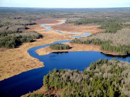
 Silver River Wilderness Area protects one of southwestern Nova Scotia’s preeminent wilderness rivers. It consists primarily of a wide corridor stretching along nearly 40 km of Silver River, through the interior of Digby and Yarmouth counties.
Silver River is one of the main branches of the Tusket River system. Beginning at Long Tusket Lake, it flows through a biologically rich landscape of conifer forest, hardwood hills and drumlins, and numerous lakes. This is in marked contrast to the less productive lands found in nearby Tobeatic Wilderness Area.
The riffs and pools of the river provide excellent fish habitat. Sandy beaches on various lakes provide nesting sites for snapping turtles, a listed species-at-risk. Though forests in parts of the wilderness area are relatively young due to past harvesting, stands of mature and old red spruce, hemlock, white pine, and sugar maple/yellow birch line much of the river and are scattered throughout. These forests provide habitat for several struggling bird species including Canada warbler and chimney swift. Though rarely encountered, the area also provides habitat for endangered mainland moose.
Protection of these lands improves representation of the Tusket River Drumlins natural landscape in the provincial protected areas network.
Silver River is a popular canoeing, kayaking, angling and camping destination. Tripping options range from day-long excursions through the scenic stillwaters in the vicinity of Barrios Lake, to multi-day trips throughout the system. The area is also popular for hunting and boating and has a long tradition of guiding and outdoor recreation.
The wilderness area can be accessed by vehicle through forest access roads that border or bisect the wilderness area. These roads are not part of wilderness area and their condition may vary. Roads within the wilderness area are, for the most part, closed to public vehicle use. In time, these will be reclaimed by forest, thereby restoring larger patches of roadless habitat which is needed or preferred by some species. Numerous traditional access points to the river (e.g., for picnicking, fishing, canoeing) are accessible by vehicle.
The New France (Electric City) archeological site is not part of the wilderness area. Vehicle use to the main parking area, the north side of Langford Lake (“The Casino”), and to a drive-in camping area on the southeast side of Little Tusket Lake is unaffected by the wilderness area.
Several existing campsite leases within the wilderness area remain in good standing.
If needed, access to private properties adjacent to the wilderness area may be authorized by the Minister of Environment.
Silver River Wilderness Area was established in 2015. In 2020, the area was expanded to its current size of 7,500 hectares (ha) with the addition of about 2,200 ha of land and waterways at the upper end of the river. This expansion was made possible through acquisition of most of the land by the Nature Conservancy of Canada (NCC), a non-government and not-for-profit land trust. NCC then transferred a portion of the acquired lands to the Province for protection. The remaining portion is still owned by NCC but is now also part of the wilderness area. As landowner, NCC continues to have the ability to make decisions on certain uses or restrictions of its land as outlined in the terms of NCC’s consent to designate this land as wilderness area. This includes a decision to allow ongoing public vehicle access to the southern end of Long Tusket Lake, but not onto or next to the adjacent beach.

