

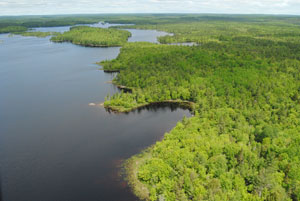
 Katewe’katik protects 1,257 hectares (ha) of woodlands and lakeshore at McGowan Lake, in Queens and Annapolis counties, within the Medway River watershed. These lands are designated under the Wilderness Areas Protection Act.
The name Katewe’katik was recommended by Mi’kmaw elders and means place of the eels. This name honours the significance of the area’s waterways to the Mi’kmaq, along with the cultural significance of eels to Mi’kmaw culture. American eel remains an important species for the subsistence fisheries of many Aboriginal communities throughout its range but is now considered at risk in some jurisdictions outside Nova Scotia.
The wilderness area includes over 10 km of shoreline on McGowan, Dean, DeLong, Martin and Eel Lakes, as well as a variety of wetlands. Much of the surrounding woodlands consists of mature and immature mixedwood and conifer forest, with hardwood forest on drumlin hills. As this forest ages, it will become increasingly important for species that prefer older forest. Older forests and wetlands can also store significant amounts of atmospheric carbon.
Protection of these landscape features helps improve representation of the LaHave Drumlins Natural Landscape in Nova Scotia’s protected areas system.
Located adjacent to Mersey Tobeatic Research Institute, Katewe’katik is a particularly important area for scientific research and education. Among other initiatives, the area has long been a focal point for research and recovery of endangered Blandings turtle and threatened ribbon snake in Nova Scotia. The wilderness area supports one of the most important concentrations of Blandings turtle in Canada.
Hunting, trapping, angling and other recreational uses are permitted at Katewe’katik, consistent with the Wilderness Areas Protection Act and other applicable legislation.
The Mount Merritt Shooting Range is not part of the wilderness area and can be accessed via Mount Merritt Road. Use of vehicles beyond the shooting range is prohibited. A few roads to adjacent private parcels pass through the wilderness area. The Minister of Environment has authority to authorize vehicle access to such properties. Old Westfield Road is not in the wilderness area and its use is not affected.
About 3.6 km of electrical transmission line and 1 km of distribution line pass through the wilderness area. Nova Scotia Power (NSPI) retains the authority to operate and maintain these powerlines and to access the dam and spillway on NSPI land at the outflow of McGowan Lake.
The Nova Scotia Nature Trust owns a peninsula and several islands in McGowan Lake totaling 26 ha. These private lands are protected in perpetuity and complement the wilderness area.