

 Gabarus Wilderness Area protects nearly 3,900 hectares of coastal lands along the Atlantic shore of Cape Breton Island, with 20 km of ocean shoreline and numerous fresh and brackish-water lakes.
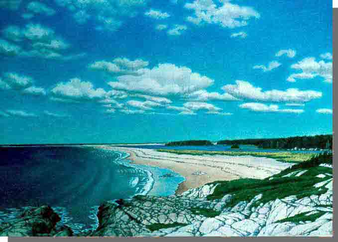
An extensive barrier beach system separates much of the exposed Atlantic shoreline from numerous brackish water lagoons and lakes. Composition of the barrier beaches ranges from cobble to sand, including dune complexes. Other parts of the shore are strewn with boulders, typically along eroding, low cliffs of glacial till and drumlins (hills formed of glacial debris, or till). This eroding glacial till is the source of material for the barrier beaches.
Studies conducted along the barrier beach system have identified at least 50 species of plants that are restricted to this ecosystem because they are adapted to the rigorous conditions of salt spray and direct sunlight. The root systems of marram grass and other plans bind beach sediments together and maintain and promote dune growth. A few of the plants which thrive here are beach pea, dusty miller, seabeach sandwort, sea-lungwort, purple angelica, iris, scotch lovage, wild strawberry, and seaside plantain. A provincially-rare fern, commonly called Grape Fern (Botrychium multifidium), occurs here.
Back from the shore is a mix of bogs, lakes, ponds, slow-moving streams, barrens, poorly drained coniferous flats, and well-drained undulating and hilly (drumlin) terrain. The uncommon lance-leaved violet (Viola lanceolata) grows in bogs and other wet sites here. A naturally-occurring zone of white spruce forest marks the boundary between coastal and terrestrial ecosystems.
Many mammals, seabirds, and shore birds may be seen at Gabarus Wilderness Area. Harbour seals and grey seals breed in the coastal zone, with adults, immatures and pups found along the shore in June and July. Mice, snowshoe hares, and red foxes (which den in the sand dunes) make their home here.
The ranges of Great Cormorants and Double-Crested Cormorants overlap here. Sugar Loaf Island, visible from Cape Gabarus, is a mixed cormorant colony - one of only five such rookeries in the province. Immature Common Eider Ducks, known locally as "Sea Ducks," feed off the outer islands and headlands during the fall and winter. Green Island, just off Cape Gabarus, has the most southerly nesting colony of Black-Legged Kittiwakes. Other resident seabirds include Common Terns and Great Black-Backed Gulls.
Migratory shorebirds reach the area throughout spring and summer, including Ruddy Turnstones (Seaweed Bird), Black-Bellied Plovers, Short-Billed Dowitchers, Great Blue Herons and Semipalmated Plovers.
With its diverse mix of protected ecosystems and landforms, Gabarus Wilderness Area offers a variety of quality wilderness recreation and wildlife viewing opportunities.
Both the open ocean and more protected Gabarus and Belfry lakes can be explored by kayak or canoe. Special care must be taken when paddling on the open ocean – conditions can change quickly. Gabarus Lake currently supports a popular sport fishery (striped bass, sea trout).
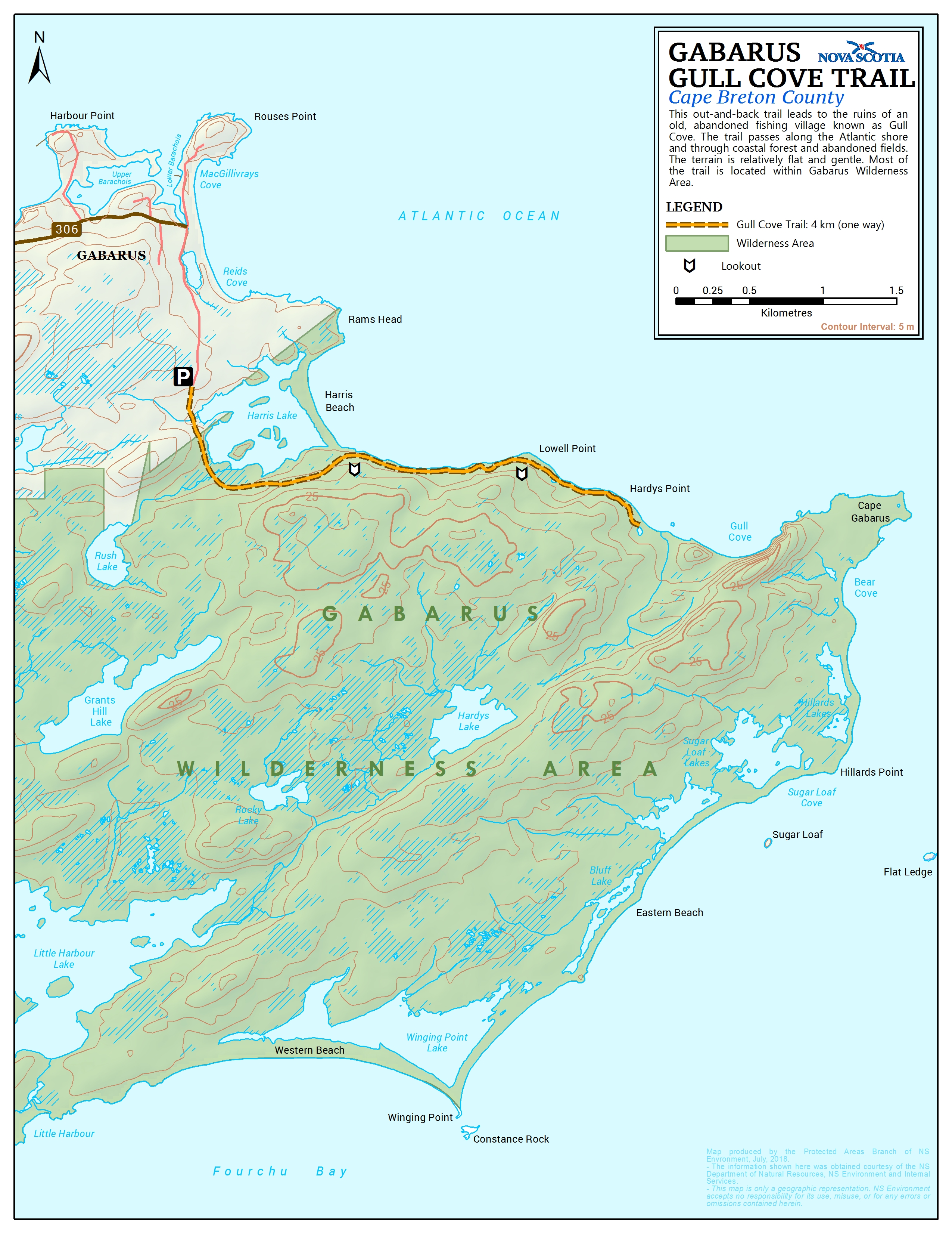
The 4 km Gull Cove Trail follows an old cart track along the northern shore of the wilderness area, between Gabarus and the former community of Gull Cove. Adventurous hikers can continue from Gull Cove to Cape Gabarus and then along the southern shore, on unmanaged trails and beach. Some areas, like Gull Cove, are suitable for camping.
Evidence of former settlements is evident at Gull Cove and other coastal sites, including old fields and meadows (colonized by white spruce) and remains of stone walls and building foundations. In the late 1800's, more than 3,000 people lived in a thriving fishing community at Gull Cove, with three schools, four churches, four stores and five lobster canneries.