| This consolidation is unofficial and is for reference only. For the official version of the regulations, consult the original documents on file with the Registry of Regulations, or refer to the Royal Gazette Part II. |
| Regulations are amended frequently. Please check the list of Regulations by Act to see if there are any recent amendments to these regulations filed with the Registry that are not yet included in this consolidation. |
| Although every effort has been made to ensure the accuracy of this electronic version, the Registry of Regulations assumes no responsibility for any discrepancies that may have resulted from reformatting. |
| This electronic version is copyright © 2010, Province of Nova Scotia, all rights reserved. It is for your personal use and may not be copied for the purposes of resale in this or any other form. |
Belleisle Marsh Protected Site Designation
made under Section 7 of the
Special Places Protection Act
R.S.N.S. 1989, c. 438
O.I.C. 2010-387 (October 21, 2010), N.S. Reg. 158/2010
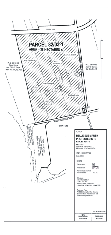
I, Percy A. Paris, Minister of Tourism, Culture and Heritage for the Province of Nova Scotia, pursuant to Section 7 of Chapter 438 of the Revised Statutes of Nova Scotia, 1989, the Special Places Protection Act, hereby designate a portion of the Belleisle Marsh described in Appendix A and shown on the map in Appendix B as a protected site.
This designation is effective on and after the date it is published in the Royal Gazette.
Dated and made at Halifax Regional Municipality, Province of Nova Scotia, , 2010 [sic].
Sgd.: Percy A. Paris
Honourable Percy A. Paris
Minister of Tourism, Culture and Heritage
Appendix A
Belleisle Marsh Protected Site
All that certain tract of land shown on a Compiled Plan Showing Belleisle Marsh Parcel 82/03-1 Protected Site and Parcel 82/03-2 Wildlife Management Area, on file at Department of Natural Resources Office at Halifax, under Field Plot P-82/03, and recorded in the Crown Land Information Management Centre as plan No. E-15-65 at Belleisle in the County of Annapolis, Province of Nova Scotia, and Parcel P-82/03-1 being more particularly described as follows;
Beginning at the intersection of the western boundary of an access road defined by document 3465 at the Crown Lands Information Management Centre and the northern boundary of the designated parking area;
Thence southwesterly along the northern boundary of the designated parking area to the northwestern corner of the designated parking area;
Thence southeasterly along the western boundary of the designated parking area to the northern boundary of an access road defined by document 3380-B at the Crown Lands Information Management Centre;
Thence southwesterly along the northern boundary of an access road defined by document 3380-B at the Crown Lands Information Management Centre, to the southeast corner of lands now or formerly conveyed to Aldon Sayre and Edith S. Sayre in book 280, page 430 at the Lawrencetown Registry of Deeds;
Thence northerly along the northeastern boundary of lands now or formerly conveyed to Aldon Sayre and Edith S. Sayre in book 280, page 430 at the Lawrencetown Registry of Deeds to a point on a southern boundary of Parcel 82/03-2;
Thence easterly along a southern boundary of Parcel 82/03-2 to the western boundary of an access road defined by document 3465 at the Crown Lands Information Management Centre;
Thence southerly along the western boundary of an access road defined by document 3465 at the Crown Lands Information Management Centre to the place of beginning.
Being and intended to be P.G.P.I. nos. 01-25-00188, 01-25-00197, 01-25-00199, 01-25-00200 and 01-25-00201.
Together with a right of way, for access purposes, over the portions of the access road described in Crown Purchase Document No. 3380-B that adjoins the southern boundary Parcel 82/03-1 and the portion of the access road (described in Purchase Document No. 3465) that adjoins the eastern boundary of Parcel 82/03-1, the eastern boundary of lands of David Eugene Cranton and Sharon Elizabeth Cranton as described in book 590, page 109 in the Lawrencetown Land Registry Office and a portion of the southern boundary of Old Highway No. 1;
Containing an approximate area of 38 hectares, more or less.
Appendix B
