| This consolidation is unofficial and is for reference only. For the official version of the regulations, consult the original documents on file with the Registry of Regulations, or refer to the Royal Gazette Part II. |
| Regulations are amended frequently. Please check the list of Regulations by Act to see if there are any recent amendments to these regulations filed with our office that are not yet included in this consolidation. |
| Although every effort has been made to ensure the accuracy of this electronic version, the Registry of Regulations assumes no responsibility for any discrepancies that may have resulted from reformatting. |
| This electronic version is copyright © 2015, Province of Nova Scotia, all rights reserved. It is for your personal use and may not be copied for the purposes of resale in this or any other form. |
Deer Hunting Regulations
made under Section 113 of the
Wildlife Act
R.S.N.S. 1989, c. 504
O.I.C. 2013-216 (June 25, 2013), N.S. Reg. 239/2013
as amended to O.I.C. 2015-239 (July 23, 2015), N.S. Reg. 286/2015
Interpretation and Application
Citation
1 These regulations may be cited as the Deer Hunting Regulations.
Definitions
2 (1) In these regulations,
“Act” means the Wildlife Act;
“antlered deer” means a deer that has an antler that is 7.62 cm or longer, measured from the head of the deer;
“antlerless deer” means a deer without antlers or with antlers that are shorter than 7.62 cm in length, measured from the head of the deer;
“antlerless deer stamp” means an antlerless deer stamp under Section 12;
“base licence” means a base licence as defined in the General Wildlife Regulations;
“bonus deer stamp” means a bonus deer stamp under Section 13;
“crossbow” means a crossbow as defined in the Firearm and Bow Regulations;
“deer hunting stamp (archery and muzzleloader)” means a deer hunting stamp (archery and muzzleloader) under Section 11;
“deer hunting stamp (general)” means a deer hunting stamp (general) under Section 10;
“deer hunting licence” means a deer hunting licence under Section 8;
“deer management zone” means an area of the Province described in Schedule “A” for which different requirements may be specified under these regulations;
“deer registration agent” means a person appointed by the Minister under Section 21 to be in charge of a deer registration station and includes an employee or person under the supervision of the person;
“deer registration confirmation number” means a unique number provided electronically by the Department when a deer is registered online in accordance with Section 22;
“deer registration station” means a deer registration station established by the Minister under Section 14 for the purpose of registering a deer killed during an open season for hunting deer;
“muzzleloader” means a muzzleloader as defined in the Firearm and Bow Regulations;
“primitive weapon” means a primitive weapon as defined in the Firearm and Bow Regulations;
“senior” means a person who is 65 years old or older;
“stamp” means a stamp issued by the Minister under Section 15 that, as part of the deer hunting licence it is affixed to, allows the holder to take, hunt or kill deer in accordance with the requirements for the stamp set out in these regulations, and includes the tag issued as part of the deer hunting licence;
“storage permit” means a permit issued under these regulations permitting the holder of the permit to possess and store the meat of a deer;
“weapon” means a weapon as defined in the Firearm and Bow Regulations;
“youth” means a person who is at least 16 years old and younger than 18 years old.
(2) In these regulations, a reference to regulations is a reference to regulations made under the Act, unless the regulations are specified to have been made under another Act.
Expressions of date periods for open seasons
3 A date period expressed in these regulations for an open season includes both the first and last date.
Subsection 3(1) renumbered Section 3: O.I.C. 2015-239, N.S. Reg. 286/2015.
Subsection 3(2) repealed: O.I.C. 2015-239, N.S. Reg. 286/2015.
Licensing and Stamps
Hunting in accordance with deer hunting licence and stamps
4 (1) A person must not take, hunt or kill deer or attempt to take, hunt or kill deer unless they hold a valid deer hunting licence.
(2) A person must not take, hunt or kill deer, or attempt to take, hunt or kill deer other than in accordance with the requirements, limitations and prohibitions set out in these regulations for the licence and stamps they are hunting under.
Bag limit for deer
5 The bag limit for deer is as follows:
(a) 1 per each of the following open seasons:
(i) the open season for hunting under a deer hunting stamp (general) set out in subsection 10(2),
(ii) the open season for hunting under a deer hunting stamp (archery and muzzleloader) set out in subsection 11(2);
(b) 1 per bonus deer stamp per calendar year, in accordance with the restrictions specified for the stamp.
Deer management zones
6 (1) The deer management zones established for the Province are as set out in Schedule A: Deer Management Zones.
(2) Only antlered deer may be taken, hunted or killed in a deer management zone, unless the Minister determines otherwise for the deer management zone under subsection (3).
(3) For any deer management zone, the Minister may determine that
(a) antlered deer and antlerless deer may be taken, hunted or killed in the deer management zone; or
(b) no deer may be taken, hunted or killed in the deer management zone.
(4) The Minister must publish any determinations made under subsection (3) on the Department’s website no later than 7 days before the beginning of the earliest open season for hunting deer.
(5) The Minister may specify the type of stamp that is required to take, hunt or kill deer in a deer management zone, including limiting hunting to 1 or more of the following:
(a) holders of deer hunting stamps (general);
(b) holders of deer hunting stamps (archery and muzzleloader);
(c) holders of antlerless deer stamps issued for the zone;
(d) holders of bonus deer stamps issued for the zone.
(6) A person must not take, hunt or kill deer in a deer management zone
(a) other than the deer management zone permitted by the stamp they are hunting under; and
(b) other than the sex or type of deer permitted for the deer management zone under this Section.
Information returns
7 No later than 7 days after the last day of the open season for hunting deer under subsection 10(2), each person who was issued a deer hunting licence during that calendar year must complete and return to the Minister any information return either issued to the licence holder or prepared by the Department for licence holders to submit information electronically.
Deer hunting licence
8 (1) A deer hunting licence is composed of a base licence and at least 1 of the following issued to the holder:
(a) a deer hunting stamp (general);
(b) a deer hunting stamp (archery and muzzleloader).
(2) A deer hunting licence is valid if any 1 or more of the stamps issued under these regulations is still valid.
Validity of stamps
9 (1) All of the following conditions must be met for a stamp to be a valid stamp:
(a) the stamp must be affixed to a base licence;
(b) the stamp’s tag must not be detached;
(c) the licence holder must not have reached the bag limit applicable to the stamp.
(2) A person must not hunt under an invalid stamp.
Deer hunting stamp (general)
10 (1) A person who holds a valid deer hunting stamp (general) may take, hunt or kill deer under the stamp in accordance with this Section.
(2) The open season for hunting deer under a deer hunting stamp (general) is the period from the last Friday in October until the first Saturday in December of the same year.
(3) A deer hunting stamp (general) permits the holder to take, hunt or kill antlered deer only, unless otherwise determined under subsection 6(3) for the deer management zone the holder is hunting in.
(4) Taking, hunting or killing deer under a deer hunting stamp (general) is not restricted to any specific deer management zone.
(5) Only weapons specified in subsection 4(1) of the Firearms and Bow Regulations for hunting big game other than moose are permitted to be used for hunting under a deer hunting stamp (general).
Deer hunting stamp (archery and muzzleloader)
11 (1) A person who holds a valid deer hunting stamp (archery and muzzleloader) may take, hunt or kill deer under the stamp in accordance with this Section.
(2) The open season for hunting deer under a deer hunting stamp (archery and muzzleloader) is the period from the 2nd Monday in September to the 2nd Saturday in December of the same year.
(3) A deer hunting stamp (archery and muzzleloader) permits the holder to take, hunt or kill antlered deer only, unless otherwise determined under subsection 6(3) for the deer management zone the holder is hunting in.
(4) Taking, hunting or killing deer under a deer hunting stamp (archery and muzzleloader) is not restricted to any specific deer management zone.
(5) Subject to subsection (6), only the primitive weapons specified in subsection 4(2) of the Firearms and Bow Regulations for hunting deer are permitted to be used for hunting under a deer hunting stamp (archery and muzzleloader).
(6) During the 2 weeks from the 2nd Monday in September to the second following Saturday of the open season in subsection (2), a person hunting under a deer hunting stamp (archery and muzzleloader) may use only a bow and arrow that is fitted with a broadhead to take, hunt, or kill deer, unless the person is hunting within a wildlife management area or game sanctuary for which other weapons are permitted by regulations applicable to the area or sanctuary.
Antlerless deer stamp
12 (1) A person must meet both of the following requirements to be eligible to be issued an antlerless deer stamp:
(a) they must be eligible to be issued a deer hunting licence;
(b) they must be a resident.
(2) An antlerless deer stamp must be used in conjunction with either a valid deer hunting stamp (general) or a valid deer hunting stamp (archery and muzzleloader) and, except as provided in this Section, is subject to all the requirements for hunting under the stamp it is used in conjunction with.
(3) A valid antlerless deer stamp permits the holder to take, hunt or kill 1 antlerless deer, instead of the deer permitted by their deer hunting licence, and does not increase the bag limit for the applicable season.
(4) Taking, hunting or killing deer under an antlerless deer stamp is restricted to the zone specified on the stamp.
Bonus deer stamp
13 (1) A person must hold 1 of the following to be eligible to be issued a bonus deer stamp:
(a) a valid deer hunting licence;
(b) a deer hunting licence that is invalid only because the tag has been detached for a stamp listed in clause 8(1)(a) or (b).
(2) A bonus deer stamp must be used in conjunction with either a deer hunting stamp (general) or a deer hunting stamp (archery and muzzleloader) issued to the holder and, except as provided in this Section, is subject to all the requirements for hunting under the stamp it is used in conjunction with.
(3) A valid bonus deer stamp permits the holder to take, hunt or kill 1 deer, in addition to the deer permitted by their deer hunting licence, and increases the bag limit for the applicable season to 2 deer.
(4) Taking, hunting or killing deer under a bonus deer stamp is restricted to the zone specified on the stamp.
(5) Taking, hunting or killing deer under a bonus deer stamp is restricted to antlered deer or antlerless deer, if the stamp specifies that it is only for one of these types of deer.
Number of antlerless deer stamps and bonus deer stamps for zones
14 The Minister may, on an annual basis, determine the number of antlerless deer stamps and bonus deer stamps to be issued in each deer management zone
(a) to persons selected randomly from among the total number of applicants that meet the requirements for the stamp; or
(b) to any person who is eligible to be issued a deer hunting licence.
Fees for stamps
15 (1) The Minister may issue the stamps listed in the table in subsection (2).
(2) Except as provided in subsection (3), the fees for stamps are as set out in the following table:
Table of Fees |
||
Stamp |
Issued to |
Fee |
deer hunting stamp (general) |
resident |
$27.87 |
non-resident |
$137.09 |
|
senior resident |
none |
|
deer hunting stamp (archery and muzzleloader) |
resident |
$27.87 |
non-resident |
$137.09 |
|
senior resident |
none |
|
bonus deer stamp |
any person |
$5.57 |
antlerless deer stamp |
resident |
paper application: $11.70 |
electronic application: $8.04 |
||
Subsection 15(2) amended: O.I.C. 2015-96, N.S. Reg. 167/2015.
(3) A deer hunting stamp (general) may be issued at no charge to a resident who is a successful participant in a random draw for the stamp carried out with the approval of the Minister.
Eligibility for deer hunting licence
16 (1) To be eligible to apply for a deer hunting licence, a person must meet all of the following conditions:
(a) they must be 16 years old or older;
(b) they must be certified under the Hunter Education, Safety and Training Regulations to hunt with the weapon they will be hunting with;
(c) for a resident deer hunting licence, they must be a resident, as defined in the Act;
(d) for youth, they must meet the application requirements in subsection (2).
(2) A deer hunting licence for a youth must be
(a) acquired by the youth’s parent or guardian; and
(b) signed by both the applicant and their parent or guardian.
Supervision of youth hunters
17 While hunting, a youth must be under the immediate supervision of 1 of the following who is certified under the Hunter Education, Safety and Training Regulations to hunt with the weapon the youth is hunting with:
(a) the youth’s parent or guardian;
(b) another responsible person who is 18 years old or older.
Special youth season for hunting deer
18 (1) Despite Sections 10 and 11, a youth who holds a deer hunting licence may hunt under the licence in accordance with these regulations during the special open season for youth in subsection (2).
(2) The special youth open season for hunting deer is defined as the period from the 1st Friday in October after October 10 until the 2nd Saturday following.
Tagging deer
19 (1) When the holder of a deer hunting licence kills a deer, that person must immediately do all of the following:
(a) detach from the licence the tag for the following applicable stamp that they are hunting under:
(i) deer hunting stamp (general),
(ii) deer hunting stamp (archery and muzzleloader);
(iii) bonus deer stamp;
(b) indicate the day and month of the kill on the deer hunting licence, as instructed on the licence;
(c) if the bag limit has been reached in accordance with subsection 12(3), cut a v-shaped notch in any antlerless deer stamp that is issued to them.
(2) Other than when registering a deer, a person who kills a deer must either
(a) ensure that the tag remains in or upon the deer carcass until it is prepared for consumption; or
(b) keep the tag on their person and stay with the deer at all times while it is being transported.
Deer Registration Stations and Agents
Establishment of deer registration stations
20 (1) The Minister may establish deer registration stations at various locations throughout the Province.
(2) The Minister must issue a public list or notice that identifies the location of deer registration stations in each county of the Province.
(3) The Department must supply all materials, equipment and signs to be used in a deer registration station.
Appointment of deer registration agents
21 (1) The Minister must appoint a deer registration agent for each deer registration station.
(2) A deer registration agent’s appointment is for 1 year from the date of the appointment.
(3) A deer registration agent’s appointment renews automatically each year unless the appointee is notified otherwise by the Minister.
Stamp or seal issued for deer registration station
22 (1) The Minister must issue a uniquely numbered seal or stamp to each deer registration agent appointed under subsection 21(1) to be used in registering deer at their deer registration station.
(2) A deer registration agent is responsible for the safe custody of the seal or stamp issued to them and must immediately report the theft or disappearance of the seal or stamp to the Department.
Deer registration agent’s reports and records
23 (1) A deer registration agent must record any information and complete any forms and reports required by the Minister.
(2) On request, a deer registration agent must submit to the Department, or make available to the Department, any records, forms or reports required under subsection (1).
Revocation of appointment of deer registration agent
24 (1) The Minister may revoke the appointment of a deer registration agent by verbal or written notice.
(2) A revocation under subsection (1) is effective when the notice is received, which, for a notice that is mailed, is deemed to be 5 days after it is mailed.
(3) A person whose appointment has been revoked must immediately deliver all of the following to the Minister:
(a) all materials, equipment and signs provided by the Department under subsection 20(3);
(b) the seal or stamp issued to them under subsection 22(1).
(4) A person must not continue to act as a deer registration agent after their appointment has been revoked.
Registering Deer
Antlered deer–pre-registration
25 A person who kills an antlered deer must ensure that the antlered head remains attached to at least one front quarter of the deer until the deer is registered.
Duty to register deer within 24 hours
26 A person who kills a deer during an open season for hunting deer must, within 24 hours of killing the deer or within 24 hours after leaving a camp used by that person to hunt deer,
(a) register the deer online under Section 30; or
(b) present the deer for registration at a deer registration station.
Possession of unregistered deer
27 A person must not possess or transport an unregistered carcass of a deer killed by another person.
Prohibitions on registration
28 (1) A person must not present a deer for registration in their name if the person did not kill the deer.
(2) A person who kills a deer must not permit another person to present the deer for registration at a deer registration station.
Registering deer at deer registration station
29 (1) To register a deer at a deer registration station, the person who killed the deer must do all of the following:
(a) personally present the deer for registration at the deer registration station;
(b) present the deer registration agent with
(i) their deer hunting licence, and
(ii) the detached tag for the deer;
(c) sign or initial a deer registration form indicating their agreement with the information recorded by the deer registration agent;
(d) pay an administration fee of $1.00.
(2) To register a deer presented at a deer registration station, a deer registration agent must do all of the following
(a) ensure the tag for the stamp is detached from the licence and that the date is indicated, as required by subsection 19(1);
(b) use a deer registration form prescribed by the Minister to register the deer;
(c) apply the seal or stamp issued for the station to the tag and the deer hunting licence so that they are clearly and distinctly marked;
(d) record the station number, name of agent and date on the tag and where indicated on the licence, and return both tag and licence to the presenter.
(3) A deer registration agent must not knowingly register a deer that
(a) was unlawfully killed;
(b) is presented by a person who did not kill it; or
(c) is presented by a person who has not complied with subsection (1) or any other provision of these regulations.
(4) A deer registration agent must immediately report a violation of these regulations to the Department or the Royal Canadian Mounted Police.
Registering deer online through Department’s website
30 To register a deer online through the Department’s website, the person who killed the deer must do all of the following:
(a) submit all information required by the Minister to register the deer in the manner the Minister directs;
(b) permanently record the deer registration confirmation number on both
(i) the detached tag for the killed deer, and
(ii) on their licence, where indicated.
Proof of registration
31 Absent any evidence to the contrary, either of the following constitutes proof of registration of a deer:
(a) a deer hunting licence completed by a deer registration agent in accordance with subsection 29(2);
(a)[(b)] a deer hunting licence and detached tag with a deer registration confirmation number recorded on it in accordance with Section 30.
Proof of registration before processing or taxidermy
32 (1) A taxidermist must not take possession of a deer or any part of a deer unless the taxidermist is shown proof of registration as prescribed by Section 31, and records the deer registration confirmation number or the deer registration station number and date.
(2) A person must not process a deer carcass for consumption unless the person is shown proof of registration as prescribed by Section 31.
Possessing and Storing Deer Meat
Storage permits for deer meat
33 (1) A person may only possess or store deer meat in accordance with this Section from a deer that was lawfully killed.
(2) Except as exempted under Section 34, a person must hold a valid storage permit to possess or store deer meat.
(3) A person may apply to the Department for a storage permit, or renewal of a storage permit, on a form issued by the Department and the Department may issue a storage permit to a person or renew a storage permit issued to a person.
(4) A deer hunting licence that meets the proof of registration requirements in Section 31 is deemed to be a valid storage permit for the licence holder to store the meat from a deer they have lawfully killed.
(5) A storage permit is valid until
(a) for a deer hunting licence that is deemed to be a storage permit under subsection (4), July 31 of the year following the year the licence is issued; or
(b) the date specified on the permit.
Exempted from storage permit
34 (1) A person may possess any part of a deer lawfully killed, other than the meat, without a storage permit.
(2) A person may possess up to 6.8 kg (15 lbs.) of deer meat from a deer lawfully killed by another person until July 31 without a storage permit if the meat is transferred to them in accordance with subsection 35(2).
Transferring deer meat
35 (1) Except as provided in subsection (2), a person who lawfully kills a deer must not transfer any deer meat to a household unless an occupant of the house holds a valid storage permit for the meat.
(2) A person who lawfully kills a deer may transfer up to the amount exempted from a storage permit under subsection 34(2) to any 1 household.
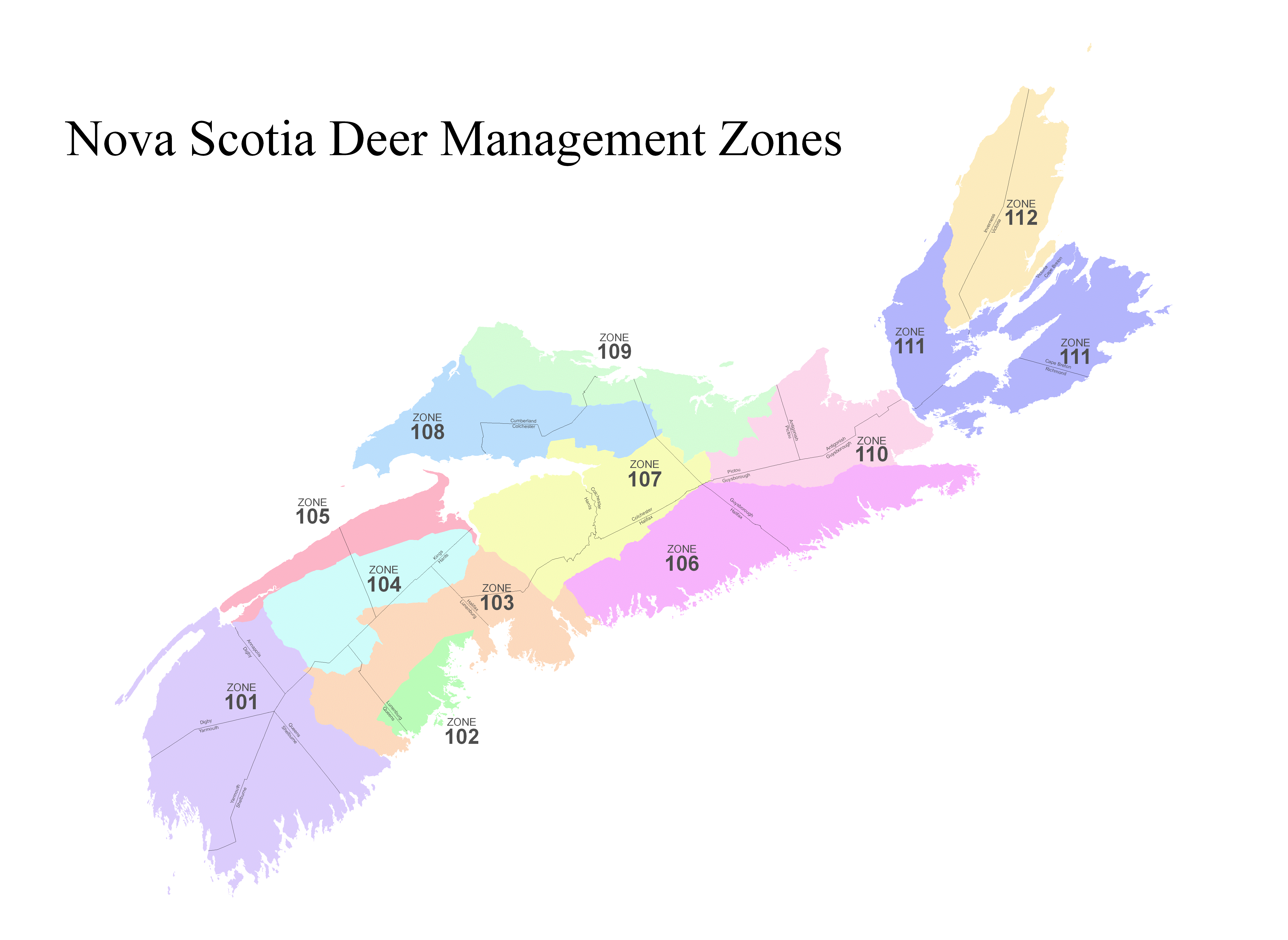
Schedule A: Deer Management Zones
Deer Management Zone 101
Deer Management Zone 101 includes certain lands within Nova Scotia, and being more particularly described as follows:
Beginning at a point in the centre of the Mersey River in Queens County where it intersects with the centre line of Highway No. 103; thence northerly along the centre line of the Mersey River through Lake Rossignol and continuing along the centre line of the Mersey River to the southern boundary of Kejimkujik National Park; thence easterly and northerly following the boundaries of Kejimkujik National Park to the western boundary of Highway Trunk No. 8 in Annapolis County; thence continuing to the centre line of Highway Trunk No. 8 in Annapolis County; thence northerly along the centre line of Trunk No. 8 to its intersection with the centre line of Highway No. 101 in Annapolis County; thence southwesterly along the centre line of Highway No. 101 to the centre of the Bear River; thence downstream along the centre of Bear River to the Annapolis Basin said point also being the Digby–Annapolis county line; thence northerly along the Digby County line, through the Digby Gut to the Bay of Fundy; thence westerly, southerly and easterly along the coastline of Nova Scotia to the mouth of Liverpool Bay; thence northerly along the centre of said Liverpool Bay to the Mersey River; thence northerly up the centre of said Mersey River to its intersection with the centre line of Highway No. 103 being the place of beginning. Together with all inland and offshore islands.
Deer Management Zone 102
Deer Management Zone 102 includes certain lands within Lunenburg and Queens Counties, Nova Scotia and are more particularly described as follows:
Beginning at a point on the centre line of the East River, Lunenburg County, where it intersects with the northernmost edge of the multi-line power transmission corridor running from Halifax County to Queens County and being approximately 1 km south of Whistler Lake; thence southwesterly along the northernmost edge of the said power transmission corridor to an angle point where the power transmission corridor separates into 2 lines; thence, following the north branch of the said transmission corridor southwesterly, passing the Gold River Indian Reserve to the north, continuing on past Lower New Cornwall to an angle point about 1 km west of the LaHave River near Cookville; thence southerly along the western edge of the said corridor, to a juncture point with the transmission line running westerly from Maitland; thence southwesterly along the northern edge of the said transmission corridor, passing to the north of Wiles Lake and Lapland, and extending to the western bank of the Medway River; thence southeasterly downstream following the western bank of the Medway River and the western shoreline of Medway Harbour to a point on the ordinary high water mark east of the navigation light at Medway Head; thence northeasterly in a straight line to a point on the ordinary high water mark of the most southerly part of Toby Island; thence northeasterly in a straight line to a point on the ordinary high water mark of the most southerly part of Cape LaHave Islands at Cape LaHave Point; thence northeasterly in a straight line to a point on the ordinary high water mark of the most eastern point of West Ironbound Island; thence northeasterly in a straight line to a point on the ordinary high water mark of the most eastern point of Cross Island; thence northeasterly in a straight line to a point on the ordinary high water mark of the most eastern point of Big Duck Island; thence northeasterly in a straight line to a point on the ordinary high water mark of the most eastern point of East Ironbound Island; thence northwesterly in a straight line to a point on the ordinary high water mark of the most northeasterly point of Little Tancook Island; thence northwesterly in a straight line to the midpoint of the mouth of East River Bay northwest from East River Point; thence northeasterly in a straight line to a point at the centre line of the mouth of East River; thence northerly following the centre line of East River to the place of beginning. Together with all inland and offshore islands.
Deer Management Zone 103
Deer Management Zone 103 includes certain lands within Nova Scotia, and being more particularly described as follows:
Beginning at a point in the centre of the Mersey River in Queens County where it intersects with the centre line of Highway No. 103; thence northerly along the centre line of the Mersey River through Lake Rossignol and continuing along the centre line of the Mersey River to the southern boundary of Kejimkujik National Park; thence easterly and northerly following the boundaries of Kejimkujik National Park to the western boundary of Highway Trunk No. 8 in Annapolis County; thence continuing to the centre line of Highway Trunk No. 8 in Annapolis County; thence southeasterly following the various courses of Highway Trunk No. 8 and crossing the Queens County line to the intersection with the centreline of the Old Westfield Road, Authority No. 499; thence northeasterly following the various courses of the centre line of the Old Westfield Road, Authority No. 499, to its intersection with the centre line of Highway No. 208 at North Brookfield; thence following the various courses of the centre line of Highway No. 208, and crossing the county line into Lunenburg County to its intersection with the centre line of Trunk No. 10 in New Germany; thence following the centre line of Trunk No. 10, and crossing the county line into Annapolis County, continuing through Springfield to the intersection with the centre line of the Falkland Ridge Road, Authority No. 566; thence following the centre line of the Falkland Ridge Road No. 566 to its intersection with the centre line of the East Dalhousie Road, Authority No. 567; thence following the centre line of the East Dalhousie Road to its intersection with the Kings–Annapolis county line; thence crossing the Kings–Annapolis county line into Kings County and following the centre line of the East Dalhousie Road, Authority No. 735, to the intersection with the Kings–Lunenburg county line; thence crossing the Kings–Lunenburg county line into Lunenburg County where the East Dalhousie Road name changes to the Forties Road; thence following the centre line of the Forties Road, Authority No. 694, to the intersection of the centre line of the Forties Road and the Windsor Road, Authority No. 686; thence following the various courses of the centre line of the Windsor Road No. 686 to the Lunenburg–Hants county line where the name of the Forties Road changes to the New Ross Road; thence following along the centre line of the New Ross Road, Authority No. 709, to the intersection with the centre line of Trunk 14; thence following the centre line of Trunk 14 to its intersection with the centre line of King Street in the Town of Windsor; thence following the centre line of King Street in a general northwesterly direction to its intersection with the centre line of Upper Water Street; thence following the centre line of Upper Water Street to the intersection with the centre line of Highway No. 101; thence following the centre line of Highway No. 101 to its intersection with the centre line of Highway No. 102 in Halifax County; thence northeasterly following the centre line of Highway No. 102 to a point perpendicular to the north end of the ordinary high water mark of Miller Lake; thence easterly and perpendicular to the centre line of Highway No. 102 to the ordinary high water mark of Miller Lake; thence following the ordinary high water mark of Miller Lake to a small brook joining Miller Lake and Soldier Lake; thence following the various courses of said brook to the western ordinary high water mark of Soldier Lake; thence following the various courses of the said ordinary high water mark of Soldier Lake in a general southerly direction to a brook known as Soldier Lake Gullies; thence following Soldier Lake Gullies in a southeasterly direction to the ordinary high water mark of Lake Major; thence following the western ordinary high water mark of Lake Major in a southeasterly direction to Little Salmon River; thence following the various courses of Little Salmon River to its intersection with the centre line of Highway No. 207; thence following the various courses of Highway No. 207 to its intersection with Lawrencetown Lake or the Atlantic Ocean; thence westerly along the Atlantic Coast to the mouth of the East River in Lunenburg County; thence in a northerly direction along the centre of the East River also being the east boundary of Deer Management Zone 102 to the intersection of the centre of the East River and the northernmost edge of the multi-line power transmission corridor running from Halifax County to Queens County and being approximately 1 km south of Whistler Lake (said transmission line being the northern boundary of Deer Management Zone 102); thence southwesterly along the northernmost edge of the said power transmission corridor to an angle point where the power transmission corridor separates into 2 lines; thence following the north branch of the said transmission corridor southwesterly, passing the Gold River Indian Reserve to the north, continuing on past Lower New Cornwall to an angle point about 1 km west of the LaHave River near Cookville; thence southerly along the western edge of the said corridor to a juncture point with the transmission line running westerly from Maitland; thence southwesterly along the northern edge of the said transmission corridor, passing to the north of Wiles Lake and Lapland, and extending to the western bank of the Medway River (being the western boundary of Deer Management Zone 102); thence southeasterly downstream following the western bank of the Medway River and the western shoreline of Medway Harbour; thence westerly along the Atlantic coast to the intersection of Liverpool Bay and the centre of the Mersey River; thence northerly upstream along the centre of said Mersey River to its intersection with the centre line of Highway No. 103 being the place of beginning. Together with all inland and offshore islands.
Deer Management Zone 104
Deer Management Zone 104 includes certain lands within Nova Scotia, and being more particularly described as follows:
Beginning at a point on the centre line of Trunk No. 8 at Lequille, Annapolis County, said point also being on the centre line of a transmission line at or near the intersection of Trunk No. 8 and the West Dalhousie Road, Authority No. 515; thence in a general northeasterly direction following the various courses of the said transmission line to its intersection with the Annapolis–Kings county line; thence in a general northeasterly direction, crossing into the County of Kings and remaining on the centre line of the transmission line to the intersection of the centre line of the transmission line and the centre line of Highway No. 101; thence following the centre line of said Highway No. 101 in a general southeasterly direction to the intersection with the Kings–Hants county line; thence easterly continuing along the centre line of said Highway No. 101, into the County of Hants and crossing the Avon River to its intersection with the centre line of Upper Water Street in the Town of Windsor; thence southerly following the centre line of Upper Water Street to its intersection with the centre line of King Street; thence southeasterly following the centre line of King Street to its intersection with the centre line of Trunk No. 14 (the Chester Road); thence southwesterly following the centre line of Trunk No. 14 (the Chester Road) to its intersection with the centre line of the New Ross Road, Authority No. 709, near Lower Vaughn; thence following the centre line of the New Ross Road No. 709 in a southwesterly direction to the county line between the counties of Hants and Lunenburg; thence crossing the said county line into the County of Lunenburg where the name of the New Ross Road changes to the Windsor Road; thence following the centre line of the Windsor Road, Authority No. 686, across the Gold River to its intersection with the Forties Road, Authority No. 694, at New Ross; thence following the various courses of the centre line of the Forties Road No. 694 to the Lunenburg–Kings county line; thence crossing the county line into Kings County where the name of the Forties Road changes to the East Dalhousie Road; thence following the centre line of the East Dalhousie Road, Authority No. 735, to the Kings–Annapolis county line; thence crossing the county line into Annapolis County and following the centre line of the East Dalhousie Road, Authority No. 567, to its intersection with the centre line of the Falkland Ridge Road, Authority No. 566; thence northwesterly and westerly following the centre line of the Falkland Ridge Road to its intersection with the centre line of Trunk No. 10, 3.3 km northwest of Springfield, Annapolis County; thence following the centre line of Trunk No. 10 in a general southerly direction and crossing the Annapolis–Lunenburg county line, entering into Lunenburg County to the intersection with the centre line of Highway No. 208 at New Germany; thence following the various courses of the centre line of Highway No. 208, Crossing the Lunenburg–Queens county line and entering into Queens County to the intersection of Authority No. 499, the Old Westfield Road, at North Brookfield; thence northwesterly following the various courses of the centre line of the Old Westfield Road No. 499 to the intersection with the centre line of Trunk No. 8; thence in a general northwesterly direction following the various courses of the centre line of Trunk No. 8, crossing the Queens–Annapolis county line, and entering into Annapolis County to Lequille, the place of beginning. Together with all inland and offshore islands.
Deer Management Zone 105
Deer Management Zone 105 includes certain lands within Nova Scotia, and being more particularly described as follows:
Beginning at a point on the centre line of Trunk No. 8 at Lequille, Annapolis County, said point also being on the centre line of a transmission line at or near the intersection of Trunk No. 8 and the West Dalhousie Road, Authority No. 515; thence in a general northeasterly direction following the various courses of the said transmission line to its intersection with the Annapolis–Kings county line; thence in a general northeasterly direction, crossing into the County of Kings and remaining on the centre line of the transmission line to the intersection of the centre line of the transmission line and the centre line of Highway No. 101; thence following the centre line of said Highway No. 101 in a general southeasterly direction to the intersection with the Kings–Hants county line; thence crossing into the County of Hants and following the centre line of said Highway No. 101 to its intersection with the centre line of the mouth of the Avon River; thence northerly along the western coastline of the Minas Basin to Cape Split; thence westerly along the Bay of Fundy to Digby Gut; thence easterly and westerly by Annapolis Basin to the centre line of Bear River; thence southeasterly by the centre line of Bear River to its intersection with the centre line of Highway No. 101; thence in a general northeasterly direction following the various courses of the centre line of Highway No. 101 to its intersection with the centre line of Trunk No. 8; thence in a general northerly direction following the centre line of Trunk No. 8 to the place of beginning. Together with all inland and offshore islands.
Deer Management Zone 106
Deer Management Zone 106 includes certain lands in the Counties of Halifax and Guysborough, Nova Scotia, and being more particularly described as follows:
Beginning at the point of intersection of the southeast boundary of Highway No. 102 with the ordinary high water mark of the northern boundary of Miller Lake; thence following the ordinary high water mark of Miller Lake to a small brook joining Miller Lake and Soldier Lake; thence following the various courses of said brook to the western ordinary high water mark of Soldier Lake; thence following the various courses of the said ordinary high water mark of Soldier Lake in a general southerly direction to a brook known as Soldier Lake Gullies; thence following Soldier Lake Gullies in a southeasterly direction to the ordinary high water mark of Lake Major; thence following the western ordinary high water mark of Lake Major in a southeasterly direction to Little Salmon River; thence following the various courses of Little Salmon River to its intersection with the centre line of Highway No. 207; thence following the various courses of Highway No. 207 to its intersection with Lawrencetown Lake or the Atlantic Ocean; thence following the various courses of the Atlantic Coast in a general easterly direction to the mouth of Chedabucto Bay; thence westerly along the southern coastline of said Chedabucto Bay to the mouth of the Salmon River in Guysborough County; thence upstream along the centre of the said Salmon River to the bridge on Highway No. 400, South River Lake Road at Ogden; thence northwesterly along the centre line of said South River Lake Road No. 400 to its intersection with Highway No. 451, the Guysborough-Country Harbour Road at Salmon River Lake; thence southwesterly along the Highway No. 451, the Guysborough-Country Harbour Road to Highway No. 480, the Country Harbour to Melrose Road (locally known as the Nine Miles Wood Road) at Country Harbour Crossroads; thence westerly along the centre line of the Melrose Country Harbour Road locally known as the Nine Mile Woods Road to its intersection with Trunk No. 7 at Melrose; thence westerly along the centre line of Route No. 348 to its intersection with the Cameron Settlement Road at Caledonia; thence westerly along the centre line of said Camero[n] Settlement Road to its intersection with Route No. 374 at Trafalgar; thence westerly along the centre line of said Route No. 374 to its intersection with the Dean Settlement Road/St. Mary’s Road; thence westerly along the centre line of the said Dean Settlement Road/St. Mary’s Road through a portion of Colchester County into Halifax County to the Lemon Hill Road at Chaplin; thence southwesterly along the Lemon Hill Road to its intersection with Route No. 336 at Dean; thence southerly along the centre line of Route No. 336 to its intersection with Route No. 224 at Upper Musquodoboit; thence westerly along the centre line of Route No. 224 to its intersection with Highway No. 427 at Elmsvale; thence southerly along Highway No. 427 to the intersection with Highway No. 425 the Higginsville Road at Newcomb Corner; thence westerly along the centre line of the Higginsville Road to Highway No. 624 the South Road at Brookvale; thence westerly along the South Road to the intersection with the centre line of Highway No. 357; thence westerly along the centre line of Highway No. 357 to the centre line of Highway No. 608, Wyses Road; thence in a general northwesterly direction following the centre line of Wyses Road to the centre line of Highway No. 212, the Old Guysborough Road, at Wyses Corner; thence westerly along the centre line of the Old Guysborough Road to its intersection with the centre line of Pratt and Whitney Drive; thence southerly along the centre line of Pratt and Whitney Drive to its intersection with the centre line of Aerotech Drive; thence following the centre line of Aerotech Drive to its intersection with the centre line of Highway No. 102; thence along the centre line of Highway No. 102 to a point being perpendicular to northern shore of Miller Lake; thence southeasterly and perpendicular to the centre line of Highway No. 102 to the northern shore of Miller Lake, the place of beginning. Including all inland and offshore islands.
Deer Management Zone 107
Deer Management Zone 107 includes certain lands within Nova Scotia, and being more particularly described as follows:
Beginning at the point where the centre line of Highway No. 101 meets with the centre line of Highway No. 102; thence northwesterly along the centre line of Highway No. 101 to its intersection with the Avon River; thence northerly downstream along the centre of the said Avon River to the Minas Basin; thence easterly and westerly along the coastline of the Minas Basin and the Cobequid Bay to the Portapique River; thence northerly along the centre of the said Portapique River to the centre line of Highway 2; thence easterly along the centre line of Highway 2 to its intersection with Route 685 at Portapique; thence northerly along the centre line of Route 685 to its intersection with Route 684 near Montrose; thence northerly along the centre line of Route 684 to Lornevale; thence easterly along the centre line of Route 684 to its intersection with Route 744 at Londonderry; thence easterly along the centre line of Route 744 to its intersection with Highway 4 near Folly Mountain; thence southerly along the centre line of Highway 4 to its intersection with Route 662; thence easterly along the centre line of Route 662 to its intersection with Route 648 at Debert; thence northerly along the centre line of Route 648 to its intersection with Route 627; thence easterly along the centre line of Route 627 to its intersection with Route 620 at Staples Brook; thence southerly, easterly and southerly along the centre line of Route 620 to its intersection with Route 624 at Belmont; thence easterly along the centre line of Route 624 to its intersection with Route 612; thence easterly along the centre line of Route 612 to its intersection with Route 614; thence southerly along the centre line of Route 614 to its intersection with Highway 104; thence easterly along the centre line of Highway 104 to its intersection with Route 821 (Cove Road); thence southerly and easterly along the centre line of Route 821 (Cove Road) to its intersection with Route 814 at Watervale; thence southerly along the centre line of Route 814 to its intersection with Route 803 at West River Station; thence easterly along the centre line of Route 803 to its intersection with Route 859; thence easterly and southeasterly along the centre line of Route 859 to its intersection with Highway 289; thence southerly along the centre line of Highway 289 to its intersection with Dryden Lake Road; thence easterly along the centre line of Dryden Lake Road to its intersection with Route 620; thence easterly along the centre line of Route 620 to its intersection with Highway 374; thence southerly along the centre line of Highway 374 to its intersection with the Dean Settlement Road/St. Mary’s Road; thence westerly along the centre line of the said Dean Settlement Road/St. Mary’s Road to its intersection with Route No. 336 at Dean; thence southerly along the centre line of Route No. 336 to its intersection with Route No. 224 at Upper Musquodoboit; thence westerly along the centre line of Route No. 224 to its intersection with Route 427 at Elmsvale; thence southerly along the centre line of Route 427 to its intersection with Route 425 at Newcomb Corner; thence westerly along the centre line of Route 425 to its intersection with Route 624 at Brookvale; thence westerly along the centre line of Route 624 to its intersection with Highway 357; thence southwesterly along the centre line of Highway 357 to its intersection with Route 608; thence northwesterly along the centre line of Route 608 to its intersection with Highway 212; thence westerly along the centre line of Highway 212 to its intersection with Pratt and Whitney Drive; thence southerly along the centre line of Pratt and Whitney Drive to Aerotech Drive; thence southerly and westerly along the centre line of Aerotech Drive to its intersection with Highway No. 102; thence southwesterly along the centre line of Highway No. 102 to its intersection with the centre line of Highway No. 101 being the place of beginning. Together with all inland and offshore islands.
Deer Management Zone 108
Deer Management Zone 108 includes certain lands within Nova Scotia, and being more particularly described as follows:
Beginning at a point at the mouth of the Parrsboro River, where it meets the Minas Basin; thence westerly following the coastline of the Minas Basin to Cape Chignecto; thence in a general northeasterly direction following the coastline of the Cumberland Basin to centre line of the mouth of the Missaguash River; thence following the various courses of the centre line of the Missaguash River to its intersection with the centre line of Highway No. 104; thence following the various courses of the centre line of Highway No. 104 in a general southeasterly direction to its intersection with the centre line of Trunk Highway No. 2; thence following the centre line of Trunk Highway No. 2 and the centre line of Junction Road to its intersection with the centre line of Highway No. 142; thence following the centre line of Highway No. 142 in a general northeasterly direction to its intersection with the centre line of Highway No. 104; thence following the various courses of the centre line of Highway No. 104 to its intersection with the centre line of Highway No. 4; thence following the various courses of the centre line of Highway No. 4 in a general easterly and southerly direction to its intersection with the centre line of Highway No. 246; thence following the various courses of Highway No. 246, and crossing the county line into Colchester County to the intersection with the centre line of Highway No. 583; thence following the centre line of Highway 583 in a southerly direction to its intersection with the centre line of Highway No. 256; thence following the various courses of the centre line of Highway No. 256 in a general easterly direction to Highway No. 311 at The Falls; thence southerly along the centre line of Highway No. 311 to Highway No. 256; thence easterly along the centre line of Highway No. 256 to Highway No. 326 at McBains Corner; thence southerly along the centre line of Highway No. 326 to Highway No. 256; thence easterly along Highway No. 256 and crossing over the county line into Pictou County, to Highway No. 736, the Loganville Road at West Branch River John; thence following the various courses of the centre line of Highway No. 736 in a general southerly direction to Highway No. 740, the Dalhousie Road; thence southerly along the centre line of Dalhousie Road to the centre line of Highway No. 739, the Glen Road at Diamond; thence following the various courses of the centre line of said Highway No. 739 in a general southerly direction to its intersection with the centre line of Trunk Highway No. 4; thence following the centre line of Trunk Highway No. 4 in a general northeasterly direction to its intersection with the centre line of Highway No. 818, the Mount Thom Road; thence following the centre line of the said Mount Thom Road in a southwesterly direction to its intersection with the centre line of Highway No. 821 the Cove Road; thence following the centre line of Highway No. 821 to its intersection with Highway No. 104; thence westerly along the centre line of Highway No. 104 to its intersection with the centre line of Route No. 614; thence northerly along the centre line of Route No. 614 to its intersection with the centre line of Route No. 612; thence westerly along the centre line of Route No. 612 to its intersection with the centre line of Route No. 624; thence westerly along the centre line of Route No. 624 to its intersection with the centre line of Route No. 620 at Belmont; thence northerly, westerly and northerly along the centre line of Route No. 620 to its intersection with the centre line of Route No. 627 at Staples Brook; thence westerly along the centre line of Route No. 627 to its intersection with the centre line of Route No. 648; thence southerly along the centre line of Route No. 648 to its intersection with Route No. 662 at Debert; thence westerly along the centre line of Route No. 662 to its intersection with the centre line of Highway No. 4; thence northerly along the centre line of Highway No. 4 to its intersection with the centre line of Route No. 744 near Folly Mountain; thence westerly along the centre line of Route No. 744 to its intersection with the centre line of Route No. 684 at Londonderry; thence westerly along the centre line of Route No. 684 to Lornevale; thence southerly along the centre line of Route No. 684 to its intersection with the centre line of Route No. 685 at Montrose; thence southerly along the centre line of Route No. 685 to its intersection with the centre line of Highway No. 2 at Portapique; thence westerly along the centre line of Highway No. 2 to its intersection with the centre line of the Portapique River; thence southerly following the centre line of the Portapique River to the coastline of the Cobequid Bay; thence following the coastline of Cobequid Bay, and Minas Basin in a general westerly direction to the mouth of the Parrsboro River, the place of beginning. Together with all inland and offshore islands.
Deer Management Zone 109
Deer Management Zone 109 includes certain lands within the Counties of Cumberland, Colchester, and Pictou and in Nova Scotia, and being more particularly described as follows:
Beginning at the point where the centre line of Highway No. 104 and the Missaquash River intersect also being on the border between the Province of Nova Scotia and the Province of New Brunswick and being in the County of Cumberland; thence northeasterly along the said border to Baie Verte; thence southeasterly along the coastline of the Northumberland Strait to the mouth of the Knoydart Brook at Knoydart Point; thence southerly along the centre of Knoydart Brook to the centre of Highway No. 245; thence westerly along Highway No. 245, 60.96 m to Highway No. 452 MacGee Road; thence southerly along the centre of Highway No. 452, MacGee Road to the Ardness to Baileys Brook Road; thence along the centre of the Ardness to Baileys Brook Road to Highway No. 449, the Arbuckle Road; thence along the centre of the Highway No. 449 to Highway No. 444, the Barneys River Road; thence along the centre of Highway No. 444, the Barneys River Road, to Highway No. 4 at Barneys River Station; thence westerly along the centre of Highway No. 4 to Highway No. 502, the French River Road; thence southerly along the centre of Highway No. 502, the French River Road, to Highway No. 347; thence northerly and westerly along Highway No. 347 to the Highway No. 532, the Blanchard Road, at Blue Mountain; thence southerly along the centre of Highway No. 532, the Blanchard Road, to Highway No. 534, the Cummings Mountain Road; thence southerly along the centre of Highway No. 534, the Cummings Mountain Road, to Highway No. 581, the Sunnybrae to Eden Road; thence westerly along the centre of Highway No. 581, the Sunnybrae to Eden Road, to Highway No. 348; thence southerly along the centre line of Highway No. 348 to the East River West Side Road; thence westerly along the centre line of the East River West Side Road to Highway No. 604, the Elgin Road, at Bridgeville; thence westerly along Highway No. 604, the Elgin Road, to Highway No. 605, the Cameron Road, at the Village of Elgin; thence westerly along the centre of Highway No. 605, the Cameron Road, to Highway No. 374; thence northerly along the centre of Highway No. 374 to Highway No. 620, the Glengarry Road; thence westerly along the centre of Highway No. 620, the Glengarry Road, to the Dryden Lake Road; thence southwesterly along the centre of the Dryden Lake Road to Highway No. 289 at Sheepherders Junction; thence northerly along the centre of Highway No. 289 to the Landsdowne Road at the Village of Landsdowne; thence northwesterly along the Landsdowne Road to the West River East Side Road No. 803; thence southwesterly along the centre line of the West River East Side Road to the West River Station Road, No. 814, at West River Station; thence northerly along the West River Station Road to the Cove Road at Watervale; thence westerly along the centre of the Cove Road and passing under Trans Canada Highway No. 104 to the Mount Thom Road; thence northerly along the Mount Thom Road to Highway No. 4; thence westerly along Highway No. 4 to the Glen Road; then northerly along the centre of the Glen Road to the Dalhousie Road, No. 740; thence northerly following the centre line of the Dalhousie Road to the Loganville Road; thence northerly along the Loganville Road to Highway No. 256; thence westerly along Highway No. 256 to Highway No. 326 at McBains Corner in Colchester County; thence northerly following the centre line of Highway No. 326 to Highway No. 256 at East Earltown; thence westerly along the centre line of Highway No. 256 to Highway No. 311 at The Falls; thence northerly along the centre line of Highway No. 311 to Highway No. 256; thence westerly following the centre line of Highway No. 256 to its intersection with Highway No. 578, the Kennedy Hill Road; thence crossing the Kennedy Hill Road, and continuing along the centre line of Highway No. 256 in a westerly direction to its intersection with Highway No. 583, the Warwick Mountain Road; thence northerly along the centre line of the Warwick Mountain Road to Highway No. 246 at West New Annan; thence westerly following the centre line of Highway No. 246 to its intersection with Highway No. 4 in Cumberland County; thence northerly along Highway No. 4 to Highway No. 104 at Thomsons Station; thence northwesterly along the centre line of Highway No. 104 to its intersection with Highway No. 142 at Salt Springs Station; thence following the centre line of Highway No. 142 in a southwesterly direction to its intersection with Junction Road at Springhill; thence northerly along the centre line of Junction Road to Highway No. 2 near Springhill; thence northwesterly following the centre line of Highway No. 2 to its intersection with Highway No. 104 at Upper Nappan; thence following the centre line of Highway No. 104 in a northwesterly direction to the place of beginning. Together with all inland and offshore islands.
Deer Management Zone 110
Deer Management Zone 110 includes certain lands within Nova Scotia, and being more particularly described as follows:
Beginning at the mouth of the Knoydart Brook at the Northumberland Strait on the Atlantic Ocean; thence northeasterly along the coastline of the Northumberland Strait to St Georges Bay; thence southeasterly along the western coastline of said St Georges Bay to the Strait of Canso; thence southerly along the centre of the said Strait of Canso to Chedabucto Bay; thence along the western coastline of the said Chedabucto Bay to the mouth of the Salmon River in Guysborough County; thence upstream along the centre of the said Salmon River to the bridge on Giants Lake Road at Ogden; thence northwesterly along the centre line of Giants Lake Road to its intersection with Highway No. 451, the Guysborough-Country Harbour Road, at Salmon River Lake; thence southwesterly along the Highway No. 451, the Guysborough-Country Harbour Road, to Highway No. 480, the Melrose Country Harbour Road (locally known as the Nine Miles Wood Road) at Country Harbour Crossroads; thence westerly along the centre line of the Melrose Country Harbour Road (locally known as the Nine Mile Woods Road) to its intersection with Trunk No. 7 at Melrose; thence westerly along the centre line of Route No. 348 to its intersection with the Cameron Settlement Road at Caledonia; thence westerly along the centre line of said Cameron Settlement Road to its intersection with Route No. 374 at Trafalgar; thence northerly along the centre line of Highway No. 374 to Highway No. 605, the Cameron Road, near Lorne, Pictou County; thence easterly along the centre of the Cameron Road to Highway No. 604, the Elgin Road at the Village of Elgin; thence easterly along the centre of the Elgin Road to the East River West Side Road at Bridgeville; thence easterly along the East River West Side Road to Highway No. 348; thence northerly along the centre line of Highway No. 348 to Highway No. 581 the Sunnybrae to Eden Road; thence easterly along the Sunnybrae to Eden Road to Highway No. 534, the Cummings Mountain Road; thence northerly along the centre of Highway No. 534, the Cummings Mountain Road, to the Highway No. 532, the Blanchard Road; thence northerly along the centre of Highway No. 532, the Blanchard Road, to Highway No. 347 at Blue Mountain; thence easterly and northerly along the centre of Highway No. 347 to Highway No. 502, the French River Road; thence northerly along the centre of the French River Road to Highway No. 4; thence easterly along the centre of Highway No. 4 to Highway No. 444, the Barneys River Road, at Barneys River Station; thence along the centre of Highway No. 444, the Barneys River Road, to Highway No. 449, the Arbuckle Road; thence northeasterly along the centre of Highway No. 449, the Arbuckle Road, to the Ardness to Baileys Brook Road; thence northeasterly along the centre of the Ardness to Baileys Brook Road to Highway No. 452, the Magee Road; thence northerly along the centre of Highway No. 452, the MacGee Road, to Highway No. 245; thence easterly along the centre of Highway No. 245, 60.96 m more or less to intersection of Highway No. 245 and the Knoydart Brook; thence northerly along the centre of the Knoydart Brook to the Atlantic Ocean at Knoydart Point on the Northumberland Strait. This point being the place of beginning. Together with all inland and offshore islands.
Deer Management Zone 111
Deer Management Zone 111 includes certain lands within Nova Scotia, and being more particularly described as follows:
Beginning at a point at the centre of the Skye River at its intersection with the centre line of Highway No. 105; thence northeasterly along the centre line of Highway No. 105 to the centre line of Highway No. 252 (Mabou Road); thence northerly along the centre line of Highway No. 252 (Mabou Road) to Highway No. 395; thence northerly along the centre line of Highway No. 395 along the east side of Lake Ainslie to the intersection with Highway No. 19 at Southwest Margaree; thence northerly along the centre line of Highway No. 19 to the intersection with the Cabot Trail at Margaree Forks; thence northerly along the centre line of said Cabot Trail to where it crosses the Margaree River at the mouth of said river; thence downstream along the centre of said Margaree River to the Gulf of St. Lawrence; thence westerly and southerly along the coastline of the Gulf of St. Lawrence and St. Georges Bay to the Strait of Canso; thence southeasterly along the centre of the Strait of Canso to Chedabucto Bay; thence easterly along the centre of Chedabucto Bay to the Atlantic Ocean; thence easterly, northerly and westerly along the coastline of the Atlantic Ocean to the mouth of Great Bras d’Or Channel; thence southwesterly along the centre of the Great Bras d’Or Channel to its mouth on the Great Bras d’Or; thence in a direct line to the eastern mouth of St. Patricks Channel; thence westerly along the centre of said St. Patricks Channel to the mouth of Whycocomagh Bay; thence northwesterly to the centre of the Skye River; thence northerly along the centre of the Skye River to its intersection with the centre line of Highway No. 105, being the place of beginning. Together with all inland and offshore islands.
Deer Management Zone 112
Deer Management Zone 112 includes certain lands within Nova Scotia, and being more particularly described as follows:
Beginning at a point at the centre of the Skye River at its intersection with the centre line of Highway No. 105; thence northeasterly along the centre line of Highway No. 105 to the centre line of Highway No. 252 (Mabou Road); thence northerly along the centre line of Highway No. 252 (Mabou Road) to Highway No. 395; thence northerly along the centre line of Highway No. 395 along the east side of Lake Ainslie to the intersection with Highway No. 19 at Southwest Margaree; thence northerly along the centre line of Highway No. 19 to the intersection with the Cabot Trail at Margaree Forks; thence northerly along the centre line of said Cabot Trail to where it crosses the Margaree River at the mouth of said river; thence downstream along the centre of the Margaree River to the Gulf of St. Lawrence; thence northeasterly along the coastline of the Gulf of St. Lawrence to Cape St. Lawrence; thence easterly, southerly and westerly along the coastline of the Gulf of St. Lawrence and the Atlantic Ocean to the Atlantic mouth of the Great Bras d’Or Channel; thence southwesterly along the centre of the Great Bras d’Or Channel to its mouth on the Great Bras d’Or; thence in a direct line to the eastern mouth of St. Patricks Channel; thence westerly along the centre of St. Patricks Channel to the mouth of Whycocomagh Bay; thence northwesterly to the centre of the Skye River; thence northerly along the centre of the Skye River to its intersection with the centre line of Highway No. 105, being the place of beginning. Together with all inland and offshore islands.
Map of Approximate Boundaries of Deer Management Zones