| This consolidation is unofficial and is for reference only. For the official version of the regulations, consult the original documents on file with the Registry of Regulations, or refer to the Royal Gazette Part II. |
| Regulations are amended frequently. Please check the list of Regulations by Act to see if there are any recent amendments to these regulations filed with our office that are not yet included in this consolidation. |
| Although every effort has been made to ensure the accuracy of this electronic version, the Registry of Regulations assumes no responsibility for any discrepancies that may have resulted from reformatting. |
| This electronic version is copyright © 2016, Province of Nova Scotia, all rights reserved. It is for your personal use and may not be copied for the purposes of resale in this or any other form. |
Five Islands Provincial Park Designation
made under Section 8 of the
Provincial Parks Act
R.S.N.S. 1989, c. 367
O.I.C. 72-337 (March 28, 1972), N.S. Reg. 122/72
O.I.C. 2015-439 (December 29, 2015), N.S. Reg. 439/2015
O.I.C. 72-337
The Governor in Council on the report and recommendation of the Minister of Lands and Forests dated the 22nd day of March, A.D., 1972, pursuant to the provisions of Section 2 of Chapter 244 of the Revised Statutes of Nova Scotia, 1967, the Provincial Parks Act, is pleased to
(a) constitute all that area of land including land covered with water owned by Her Majesty in right of the Province of Nova Scotia and situate at Five Islands, in the County of Colchester, Province of Nova Scotia, to be a provincial park, said area of land being included within the boundaries of the lands described in Schedule “A” attached to the report and recommendation and shown outlined on the Plan of Survey marked Schedule “B” also attached to the report and recommendation; and
(b) declare the name by which the park shall be known as “Five Islands Provincial Park”.
Schedule “A”
Five Islands Provincial Park
All those certain lots, pieces or parcels of lands situate at Five Islands, County of Colchester, Province of Nova Scotia, shown as Lot “A” and Lot “B” on plan number E-5-13 recorded in the Crown Land Records Office, Department of Lands and Forests, Halifax, and being more particularly described as follows:
Lot “A”
Beginning at a stake situated at the intersection of the southerly boundary of Highway Number 2 leading from Truro to Amherst with the easterly boundary of the Public Road leading into the Park lands;
From thence (by astronomic bearings) north eighty-five degrees thirty-four minutes east, one hundred ninety-eight decimal zero feet along the southerly boundary of the said Highway No. 2 to a stake;
Thence south four degrees twenty-six minutes east, sixty-six decimal zero feet to a stake;
Thence south eighty-five degrees thirty-four minutes west, one hundred thirty-two decimal zero feet to a stake;
Thence south one degree thirteen minutes east, six hundred seven decimal eighty-six feet to a stake;
Thence south sixty-four degrees five minutes west, one hundred six decimal twenty-six feet to a stake;
Thence in a southwesterly direction and maintaining a distance of one hundred thirty-two feet from the centreline of the Public Road leading to the Park area to Crown Land iron post number C1005;
Thence south four degrees thirty-two minutes forty-six seconds west, nine hundred sixteen decimal ninety-four feet to a point;
Thence south seven degrees eight minutes ten seconds west, two hundred thirty-six decimal twenty-one feet to an iron post;
Thence south five degrees thirty-nine minutes four seconds west, three hundred sixty-three decimal thirty-three feet to an iron post;
Thence south five degrees fifty-nine minutes sixteen seconds west, seven hundred thirty-six decimal sixty-three feet to an iron post;
Thence south four degrees twenty-nine minutes forty seconds west, five hundred seventy-one decimal sixty-nine feet to an iron post;
Thence south six degrees fifty-three minutes forty seconds west, four hundred six decimal forty-nine feet to an iron post;
Thence south eight degrees fifty-nine minutes sixteen seconds west, seven hundred fifty-one decimal ninety-four feet to an iron post;
Thence south four degrees three minutes twenty seconds east, two hundred twenty-seven decimal forty-four feet to an iron post;
Thence south four degrees thirty-eight minutes four seconds west, one thousand six hundred seventy-two decimal thirty-one feet to Crown Land iron post number C1004;
Thence continuing south four degrees thirty-eight minutes four seconds west, one thousand two hundred decimal zero feet to a point in the waters of Minas Basin;
Thence north seventy-five degrees fifty-one minutes fifty-six seconds west, seven thousand nine hundred thirty decimal zero feet to a point in the waters of Minas Basin;
Thence north zero degrees thirty-eight minutes four seconds east, four thousand six hundred fifty decimal zero feet to a point in the waters of Minas Basin;
Thence south seventy degrees thirty-six minutes fifty-six seconds east, one thousand nine hundred seventy decimal zero feet to a point in the waters of East River;
Thence north fifty-five degrees, thirty-six minutes forty-three seconds east, four thousand two hundred eighty-six decimal thirty-three feet to Crown Land iron post number C1008, said iron post being on the southeast shore of the East River;
Thence south eighty-five degrees six minutes two seconds east, one thousand eight hundred seventy-nine decimal eighty-eight feet to Crown Land iron post number C1007;
Thence south four degrees twenty-five minutes forty seconds west, one thousand three hundred five decimal seventy-four feet to Crown Land iron post number C1006, said iron post being south eighty-one degrees fifty-five minutes forty-six seconds west, one thousand one hundred twenty-three decimal fifty-two feet from aforementioned Crown Land iron post number C1005;
Thence in a northeasterly direction and maintaining a distance of one hundred thirty-two feet from the centreline of the public road leading to the park area to Crown Land iron post number C1013, said iron post being north fifty-four degrees seven minutes forty-four seconds east, one thousand seven hundred twenty-one decimal zero two feet from aforementioned Crown Land iron post number C1005;
Thence north five degrees forty-one minutes twenty-nine seconds east, one thousand four hundred eighty-two decimal forty-nine feet to Crown Land iron post C1014;
Thence south sixty-two degrees seven minutes forty-two seconds east, six hundred seventy-five decimal sixty-four feet to Crown Land iron post number C1015;
Thence south twelve degrees thirty minutes fifty-six seconds east, three hundred ninety-nine decimal eighty-nine feet to an iron post;
Thence north sixty-one degrees thirteen minutes east, five hundred ten decimal eighteen feet to a stake;
Thence north twenty-two degrees forty-five minutes west, four hundred ninety-five decimal sixty-six feet to a stake being on the southerly boundary of Highway Number 2 leading from Truro to Amherst;
Thence north eighty-five degrees thirty-four minutes east, four hundred fifty decimal twelve feet along the southerly boundary of aforementioned Highway Number 2 to a stake marking the place of beginning containing eight hundred seventeen acres more or less not including lands covered by the waters of Minas Basin and East River;
Excepting and reserving therefrom any public road right-of-way, grants of easements for public utilities and any grants of right-of-way to the releasors of the above described lands.
Lot “B”
Beginning at Crown Lands iron post number C1009, said iron post being south eighty-two degrees twenty-one minutes seven seconds east, four hundred thirty-five decimal twenty-seven feet from aforementioned Crown Land iron post number C1007 in Lot “A”;
From thence (by astronomic bearings) north four degrees nineteen minutes fifty-two seconds east, one thousand nine decimal zero seven feet to an iron post;
Thence north nine degrees five minutes fifty-nine seconds east, six hundred fifty-eight decimal zero two feet to Crown Land iron post number C1012;
Thence in a southeasterly direction along an old fence to Crown Land iron post number C1011, said iron post being south fifty-three degrees thirty-two minutes fifty-three seconds east, eight hundred ninety-four decimal seventeen feet from aforementioned Crown Land iron post number C1012;
Thence south thirteen degrees sixteen minutes thirty-one seconds west, one thousand two hundred forty decimal seventy-three feet to Crown Land iron post number C1010;
Thence north eighty-two degrees twenty-one minutes seven seconds west, six hundred nineteen decimal forty-one feet to Crown Land iron post number C1009 marking the place of beginning containing twenty-three acres more or less.
Excepting and reserving therefrom any public road right-of-way, grant of easements for public utilities and any grants of right-of-way to the releasors of the above described lands.
Schedule “B”
[Note: The map referred to as Schedule “B” was not filed with the Office of the Registrar of Regulations.]
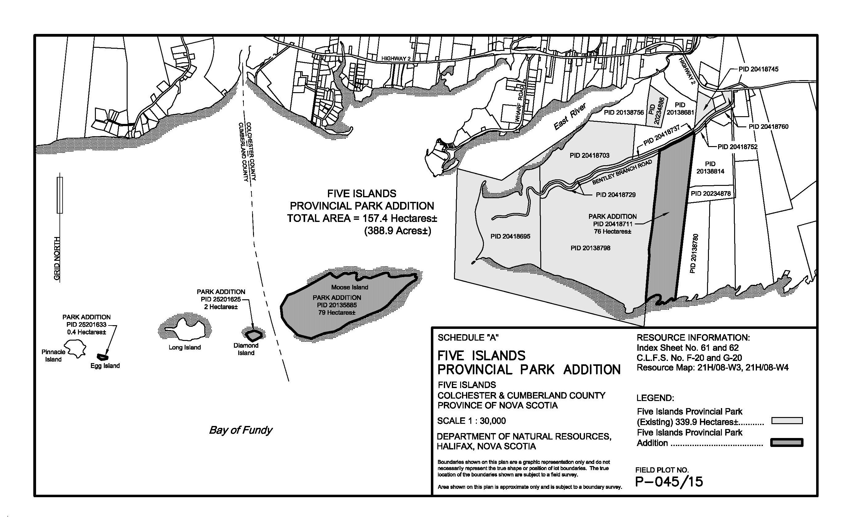
O.I.C. 2015-439
The Governor in Council on the report and recommendation of the Minister of Natural Resources dated December 3, 2015, and pursuant to Section 8 of Chapter 367 of the Revised Statutes of Nova Scotia, 1989, the Provincial Parks Act, is pleased, effective on and after December 29, 2015, to:
(a) increase the size of Five Islands Provincial Park, originally designated by the Governor in Council by Order in Council 72-337 dated March 28, 1972, by adding existing Crown lands shown outlined in bold on the plan marked Schedule “A” attached to and forming part of the report and recommendation; and
(b) authorize the Minister of Natural Resources to execute such documents as may be necessary to achieve the purposes of this Order.
Schedule “A”
Five Islands Provincial Park Addition