| This consolidation is unofficial and is for reference only. For the official version of the regulations, consult the original documents on file with the Office of the Registrar of Regulations, or refer to the Royal Gazette Part II. |
| Regulations are amended frequently. Please check the list of Regulations by Act to see if there are any recent amendments to these regulations filed with our office that are not yet included in this consolidation. |
| Although every effort has been made to ensure the accuracy of this electronic version, the Office of the Registrar of Regulations assumes no responsibility for any discrepancies that may have resulted from reformatting. |
| This electronic version is copyright © , Province of Nova Scotia, all rights reserved. It is for your personal use and may not be copied for the purposes of resale in this or any other form. |
Pugwash Protected Water Area Designation
made under subsections 106(1) and (6) of the
N.S. Reg. 86/2022 (effective May 3, 2022)
Table of Contents
Please note: this table of contents is provided for convenience of reference and does not form part of the regulations.
Click here to go to the text of the regulations.
Schedule “A” Pugwash Protected Water Area Boundary Description
Appendix A–Map of Approximate Boundaries of Pugwash Protected Water Area
In the matter of subsections 106(1) and (6) of
Chapter 1 of the Acts of 1994-95, the Environment Act
- and -
In the matter of the designation of an area surrounding the Pugwash wellfield,
in the County of Cumberland, as a Protected Water Area to be known as
the Pugwash Protected Water Area
Whereas Section 106 of Chapter 1 of the Acts of 1994-95, the Environment Act, provides for the designation by the Minister of Environment and Climate Change of a protected water area and the making of regulations under subsection (6) to prohibit, regulate or require the doing of any act or acts in a protected water area that may impair or prevent the impairment, as the case may be, of the quality of the water in the Protected Water Area;
And whereas the operator of the Pugwash wellfield, the Municipality of the County of Cumberland has requested that the Minister of Environment designate the Pugwash wellfield as a Protected Water Area in order to protect the quality of the surface water and groundwater resource as a water supply;
And whereas the Municipality of the County of Cumberland has provided opportunities for public consultation, including public meetings and the establishment of the Pugwash Wellfield Advisory Committee, an advisory committee comprising representatives of the Province of Nova Scotia, the Municipality of the County of Cumberland, members of the general public and landowners;
Therefore pursuant to Section 106 of Chapter 1 of the Acts of 1994-95, the Environment Act, the undersigned, Tim Halman, Minister of Environment and Climate Change hereby
(a) designates an area comprising the area surrounding the Pugwash wellfield and more fully described in Schedule “A” as a protected water area to be known as the “Pugwash Protected Water Area”; and
(b) makes regulations respecting activity in the Pugwash Protected Water Area, in the form set forth in Schedule “B”.
This order is effective on and after the date it is made.
Dated and made May 3, 2022, at Halifax Regional Municipality, Province of Nova Scotia.
sgd. T. Halman
Honourable Tim Halman
Minister of Environment and Climate Change
Pugwash Protected Water Area Boundary Description
All that certain area of land lying northwest of the Pugwash River Road and southeast of Highway #321, County of Cumberland and Province of Nova Scotia, shown as the Limit of the Protected Water Area on Plan of Pugwash Water Supply, prepared by Michael J. Gould, N.S.L.S., the Limit of the Protected Water Area being more particularly described as follows:
Beginning at a survey marker denoted as 56 on the aforesaid plan, being on the northeast side of Crowe Road at the intersection of the northwest boundary of Parcel “K”, and having co-ordinates (relative to Nova Scotia Co-ordinate Grid 3 deg. MTM Zone 5 Central Meridian 64 deg. 30 min. West Longitude) N 5074077.123 E 25558715.677;
Thence 21 deg. 00 min. 57 sec. for a distance of 277.601 metres to a survey marker denoted as 1005 on the aforesaid plan;
Thence 21 deg. 00 min. 57 sec. for a distance of 225.797 metres to a survey marker denoted as 1007 on the aforesaid plan;
Thence 21 deg. 28 min. 19 sec. for a distance of 300.230 metres to a survey marker denoted as denoted as 355 on the aforesaid plan;
Thence 6 deg. 06 min. 38 sec. for a distance of 193.474 metres to a survey marker denoted as 961 on the aforesaid plan;
Thence 38 deg. 42 min. 23 sec. for a distance of 371.444 metres to a survey marker stamped C-3813 and denoted as 1202 on the aforesaid plan;
Thence 80 deg. 10 min. 08 sec. for a distance of 654.536 metres to a found survey marker stamped C-3678 and denoted as 1911 on the aforesaid plan;
Thence 17 deg. 55 min. 04 sec. for a distance of 155.905 metres along a found blazed line to a survey marker denoted as 964 on the aforesaid plan;
Thence 129 deg. 24 min. 52 sec. for a distance of 95.038 metres to a survey marker denoted as 421 on the aforesaid plan;
Thence 130 deg. 35 min. 18 sec. for a distance of 771. 171 metres to a survey marker denoted as 2601 on the aforesaid plan;
Thence 203 deg. 42 min. 42 sec. for a distance of 183.722 metres to a survey marker denoted as 326 on the aforesaid plan;
Thence 203 deg. 42 min. 42 sec. for a distance of 212.920 metres to a survey marker denoted as 240 on the aforesaid plan;
Thence 195 deg. 54 min. 27 sec. for a distance of 191.849 metres to a survey marker denoted as 244 on the aforesaid plan;
Thence 225 deg. 18 min. 15 sec. for a distance of 236.032 metres along a found blazed line to a survey marker denoted as 247 on the aforesaid plan;
Thence 229 deg. 06 min. 16 sec. for a distance of 382.002 metres to a survey marker denoted as 2603 on the aforesaid plan;
Thence 229 deg. 06 min. 16 sec. for a distance of 223.561 metres to a survey marker set on the northeast side of Crowe Road, denoted as 2604 on the aforesaid plan;
Thence 229 deg. 06 min. 16 sec. for a distance of 20.510 metres to a survey marker set on the southwest side of Crowe Road, denoted as 2605 on the aforesaid plan;
Thence 229 deg. 06 min. 16 sec. for a distance of 218.437 metres to a survey marker denoted as 671 on the aforesaid plan;
Thence 231 deg. 03 min. 23 sec. for a distance of 177.214 metres to a survey marker denoted as 2602 on the aforesaid plan;
Thence 231 deg. 03 min. 23 sec. for a distance of 173.327 metres to a survey marker stamped C-1543 and denoted as 1543 on the aforesaid plan;
Thence 192 deg. 16 min. 07 sec. for a distance of 170.167 metres to a survey marker stamped C-1389 and denoted as 1389 on the aforesaid plan;
Thence 305 deg. 49 min. 49 sec. for a distance of 246.921 metres along a found blazed line and wire fence to a survey marker stamped C-3677 and denoted as 2541 on the aforesaid plan;
Thence 307 deg. 42 min. 04 sec. for a distance of 418.110 metres along a found blazed line and wire fence to a found survey marker stamped C-2299 and denoted as 2546 on the aforesaid plan;
Thence 36 deg. 25 min. 07 sec. for a distance of 216.283 metres to a found survey marker stamped C-2298 and denoted as 1019 on the aforesaid plan;
Thence 36 deg. 25 min. 07 sec. for a distance of 15.732 metres to a point denoted as 2600 on the aforesaid plan;
Thence 307 deg. 59 min. 55 sec. for a distance of 222.001 metres to the place of beginning; (Directions in the preceding are oriented to the NAD83 Nova Scotia Co-ordinate Grid 3 deg. MTM Zone 5 Central Meridian 64 deg. 30 min. West Longitude)
The above described Pugwash Protected Water Area having an area of 232.5 hectares.
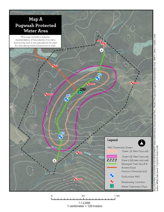
The boundaries set out above are approximated on the map attached as Appendix A.
Appendix A–Map of Approximate Boundaries of Pugwash Protected Water Area
Legislative History
Reference Tables
Pugwash Protected Water Area Designation |
N.S. Reg. 86/2022 |
Environment Act |
|
Note: The information in these tables does not form part of the regulations and is compiled by the Office of the Registrar of Regulations for reference only. |
|
Source Law
The current consolidation of the Pugwash Protected Water Area Designation made under the Environment Act includes all of the following regulations:
N.S. |
In force |
How in force |
Royal Gazette |
86/2022 |
May 3, 2022 |
date specified |
May 20, 2022 |
|
|
|
|
|
|
|
|
|
|
|
|
|
|
|
|
The following regulations are not yet in force and are not included in the current consolidation:
N.S. |
In force |
How in force |
Royal Gazette |
|
|
|
|
|
|
|
|
|
|
|
|
*See subsection 3(6) of the Regulations Act for rules about in force dates of regulations.
ad. = added |
fc. = fee change |
rep. = repealed |
|
Provision affected |
How affected |
||
.......................................................... |
|
||
|
|
||
|
|
||
|
|
||
|
|
||
Note that changes to headings are not included in the above table.
Editorial Notes and Corrections
|
Note |
Effective |
|
|
|
|
|
|
|
|
|
Repealed and Superseded
N.S. |
Title |
In force |
Repealed |
|
|
|
|
Note: Only regulations that are specifically repealed and replaced appear in this table. It may not reflect the entire history of regulations on this subject matter.