The Economics and Statistics Division maintains archives of previous publications for accountability purposes, but makes no updates to keep these documents current with the latest data revisions from Statistics Canada. As a result, information in older documents may not be accurate. Please exercise caution when referring to older documents. For the latest information and historical data, please contact the individual listed to the right.
<--- Return to Archive
For additional information relating to this article, please contact:
November 21, 2022URBAN GREENNESS, 2022 Statistics Canada has published estimates of 'urban greenness' as part of its Census on the Environment. Urban greenness refers to the share of public and private land in built up areas that are covered in the summer with healthy vegetation. This includes green spaces in urban areas and excludes bodies of water.
In Nova Scotia, 93.8% of land area in all population centres was green - with higher shares in small population centres and lower shares in large and medium urban areas.
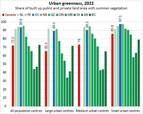
Across Canada, 72.2% of population centres were covered with healthy summer vegetation. Urban greenness was highest in Atlantic Canada and lowest in Alberta and Saskatchewan.
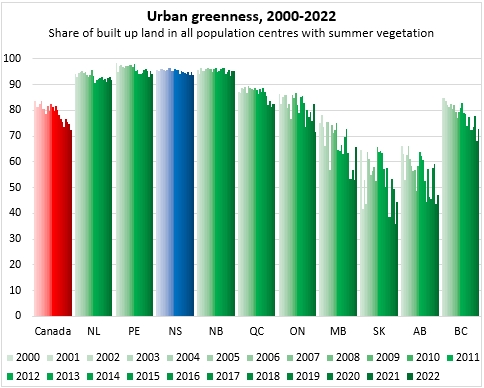
Over time, urban greenness has been declining in central and western provinces, while urban greenness in Atlantic Canada has been more stable.
Within Nova Scotia, urban greenness has been declining for Halifax (large urban centre) as well as Cape Breton-Sydney (medium urban centre), while smaller population centres in Nova Scotia maintained over 97% urban green cover.
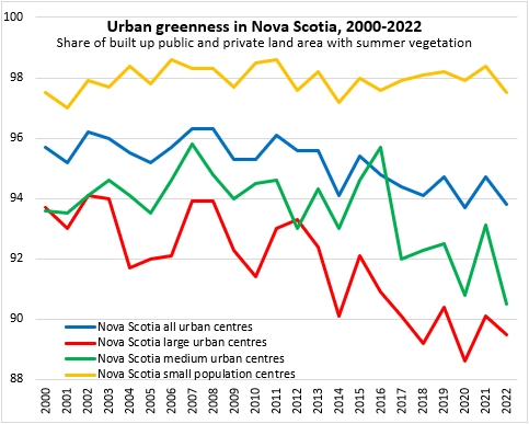
Nova Scotia small population centres: Shelburne, Yarmouth, Liverpool, Digby, Kingston-Greenwood, Middleton, Berwick, Centreville, Hayes Subdivision (Coldbrook), Kentville, Port Williams, Wolfville, Bridgewater, Lunenburg, Chester, Windsor, Hantsport, Indian Brook, Enfield-Lantz, Stillwater Lake (Tantallon), Brookside, Lake Echo, Truro, Springhill, Amherst, New Glasgow, Pictou, Antigonish, Port Hawkesbury, Inverness, Eskasoni, Howie Centre, Sydney Mines, New Waterford, Glace Bay
Source: Statistics Canada. Table 38-10-0158-01 Urban greenness and normalized difference vegetation index by 2021 population centre
<--- Return to Archive