The Economics and Statistics Division maintains archives of previous publications for accountability purposes, but makes no updates to keep these documents current with the latest data revisions from Statistics Canada. As a result, information in older documents may not be accurate. Please exercise caution when referring to older documents. For the latest information and historical data, please contact the individual listed to the right.
<--- Return to Archive
For additional information relating to this article, please contact:
May 24, 2022INFRASTRUCTURE: ROADS AND BRIDGES, 2020 
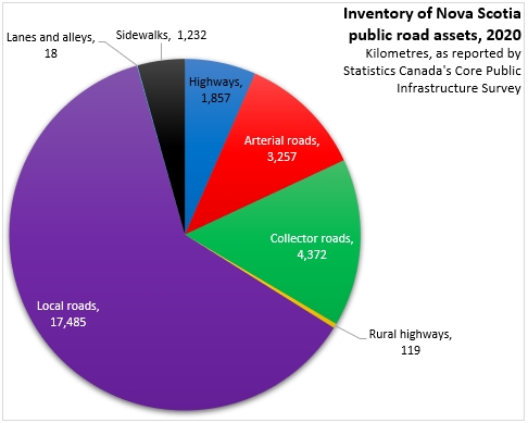
Statistics Canada has released new infrastructure data on publicly owned roads and bridges for 2020. In 2020, Nova Scotia had 28,340 kilometres of publicly owned highways and roads. The largest portions of Nova Scotia roads are local roads, followed by collector and arterial roads.
Across Canada, local roads are also the largest part of each province's road network. Saskatchewan reports a notably higher amount of public road kilometres than any other province.
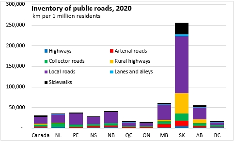
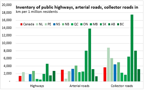
On a per capita basis, Nova Scotia has more highways, arterial, collector and local roads than the national average. Saskatchewan reports the largest amount of these roads per capita while the smallest amounts were reported in Ontario and Quebec (and British Columbia for arterial and local roads).

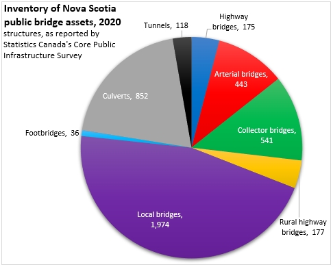
Nova Scotia also reports 4,316 bridge, culvert and tunnel structures in 2020. Almost half of these were local bridges.
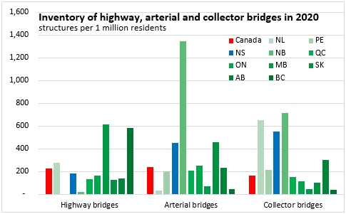
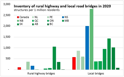
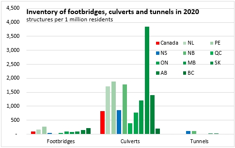
The amount of bridge, culvert and tunnel structures per capita was highest in Saskatchewan and New Brunswick, followed by Nova Scotia.

Compared with the national number of bridge, culvert and tunnel structures per capita, Nova Scotia has more arterial, collector, local and rural highway bridges as well as culverts (here referring only to those with diameters greater than or equal to 3 metres).
Definitions from Statistics Canada's Core Public Infrastructure Survey
- Highways are defined as roads that move high volumes of traffic and have controlled entrance and exit, a dividing strip between the traffic in opposite directions, and typically two or more lanes in each direction. Highways do not provide access to property, and generally do not accommodate cyclists or pedestrians.
- Rural highways are defined as roads that move varied traffic volumes depending on location, are medium to high speed, and are usually one, but sometimes two lanes in each direction. These highways usually have no dividing strip and allow for direct access from adjacent developments.
- Arterial roads are defined as roads that move moderate to high traffic volumes over moderate distances between principal areas of traffic generation, and gather traffic from collector roads and local roads and move it to the highway system. Arterial roads are generally designed for medium speed, have capacity for 2 to 6 lanes, and may be divided, with limited or controlled direct access from adjacent developments and with on-street parking discouraged.
- Collector roads are defined as roads that move low to moderate traffic volumes within specific areas of a municipality and collect local traffic for distribution to the arterial or highway system. Collector roads are generally designed for medium speed, have capacity for 2 to 4 lanes, are usually undivided, with direct access from adjacent development permitted but usually controlled, and with controlled on-street parking usually permitted.
- Local roads are defined as roads that provide for low volumes of traffic and access to private properties; local roads are designed for low speeds, have capacity for 2 undivided lanes of traffic; through traffic is discouraged and parking is usually permitted though often controlled.
Data are based on responses from approximately 2,260 government organizations. The following organizations are included in the survey:
- provincial and territorial departments and ministries
- regional governments
- urban and rural municipalities
- selected provincial Crown corporations and public transit authorities.
Road lengths have been reported in terms of two-lane equivalent kilometres, where one kilometre of a four-lane highway is counted as two kilometres.
Sources: Statistics Canada. Table 17-10-0005-01 Population estimates on July 1st, by age and sex; Table 34-10-0176-01 Inventory of publicly owned road assets, Infrastructure Canada; Table 34-10-0078-01 Inventory of publicly owned bridge and tunnel assets, Infrastructure Canada
<--- Return to Archive