| This consolidation is unofficial and is for reference only. For the official version of the regulations, consult the original documents on file with the Registry of Regulations, or refer to the Royal Gazette Part II. |
| Regulations are amended frequently. Please check the list of Regulations by Act to see if there are any recent amendments to these regulations filed with the Registry that are not yet included in this consolidation. |
| Although every effort has been made to ensure the accuracy of this electronic version, the Registry of Regulations assumes no responsibility for any discrepancies that may have resulted from reformatting. |
| This electronic version is copyright © 2009, Province of Nova Scotia, all rights reserved. It is for your personal use and may not be copied for the purposes of resale in this or any other form. |
MacFarlane Woods Nature Reserve Ecological Site Designation
made under Section 14 of the
Special Places Protection Act
R.S.N.S. 1989, c. 438
O.I.C. 88-605 (June 7, 1988), N.S. Reg. 128/88
and O.I.C. 2004-474 (December 3, 2004), N.S. Reg. 240/2004
O.I.C. 88-605
The Governor in Council on the report and recommendation of the Minister of Education dated the 18th day of May, 1988, pursuant to subsection (1) of Section 14 of Chapter 17 of the Statutes of Nova Scotia, 1980, the Special Places Protection Act, is pleased to designate the land described in Schedule “A” attached to the report and recommendation as the MacFarlane Woods Nature Reserve, effective the 8th day of June, 1988.
Schedule “A”
All that certain lot, piece, parcel or tract of land situate, lying and being at Mull River, Inverness County, Province of Nova Scotia, shown outlined in red on a plan, Field Plot
P-015/88 on file at the Department of Lands and Forests office at Dartmouth, marked Schedule “B” attached hereto and forming part of this indenture, said lot being more particularly bounded and described as follows:
Beginning at a survey marker (L.F.T. I3323) located at the southeast corner of grant 13256 to James McLeod;
Thence following the northeasterly boundary of grant 13256 to James McLeod, (by Grid Azimuth) 299o 32' 35" distant 86.07' to survey marker (L.F.T. I3322) located at the southwest corner of grant Book Q, Page 88 to Allan Cameron;
Thence following the southeasterly boundary of grant Book Q, Page 88 to Allan Cameron, 26o 47' 00" distant 1649.81" to survey marker (L.F.T. I3321) located at the southeast corner of grant Book Q, Page 88 to Allan Cameron and being the southeast corner of grant Book V, Page 223 to Alexander McDonald;
Thence following the southeasterly boundary of grant Book V, page 223 to Alexander McDonald, 26o 47' 40" distant 142.09' to survey marker I3320;
Thence 120o 34' 25" distant 3063.63' to survey marker I3319;
Thence 120o 34' 10" distant 2459.82' to survey marker I3318 located on the northerly boundary of the public highway;
Thence following the northwesterly boundary of the public highway, 234o 02' 58" distant 352.35' to survey marker I3317;
Thence 300o 30' 53" distant 2333.41' to survey marker I3316;
Thence 257o 53' 32" distant 3737.61' to survey marker I3315 located on the northeasterly boundary of the Mabou Ridge Road;
Thence following the northeasterly boundary of the Mabou Ridge Road 327o 13' 00" distant 33.06' to survey marker I3324 located on the southeasterly boundary of grant 13256 to James McLeod.
Thence following the southeasterly boundary of grant 13256 to James McLeod 26° 53' 45" distant 1060.13' to the place of beginning.
The above described parcel of land contains an area of 129.84 acres, more or less.
All above described Azimuths and distances are grid, based on the Nova Scotia Coordinate System, Zone 4, Central Meridian 61o 30' west, Scale Factor 0.999879, Coordinate values dated July 1979.
The above described land is a portion of lands conveyed to James St. Clair by deed recorded at the Registry of Deeds, Port Hood in Registry Book 61, Page 309.
O.I.C. 2004-474
The Governor in Council on the report and recommendation of the Minister of Environment and Labour dated October 26, 2004, and pursuant to Section 14 of Chapter 438 of the Revised Statutes of Nova Scotia, 1989, the Special Places Protection Act, is pleased to approve the designation by the Minister of the Environment and Labour of certain additional lands to the ecological site known as MacFarlane Woods Nature Reserve, in the manner set forth in Schedule “A” attached to and forming part of the report and recommendation.
Designation of certain lands at Mull River, Inverness County, as an addition to
MacFarlane Woods Nature Reserve ecological site
by the Minister of Environment and Labour and approved by the Governor in Council
pursuant to subsections (1), (2) (3) and (4) of Section 14 of Chapter 438 of
the Revised Statutes of Nova Scotia, 1989, the Special Places Protection Act
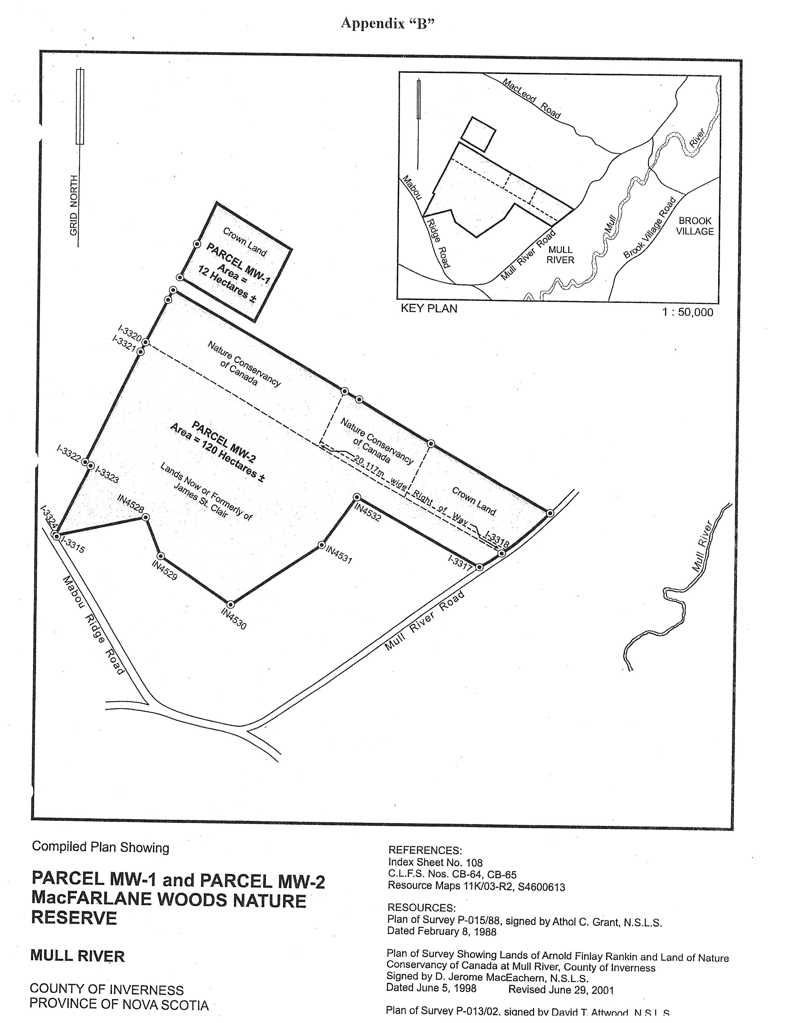
Pursuant to subsections (1), (2), (3), and (4) of Section 14 of Chapter 438 of the Revised Statutes of Nova Scotia, 1989, the Special Places Protection Act, I hereby designate certain lands as an addition to the ecological site known as MacFarlane Woods Nature Reserve, which was designated under O.I.C. 88-605 on June 7, 1988. The additional lands hereby designated, together with lands previously designated under O.I.C. 88-605, are described in Appendix “A” and shown as Parcel MW-1 and Parcel MW-2 on Compiled Plan Showing Parcel MW-1 and Parcel MW-2 MacFarlane Woods Nature Reserve, attached as Appendix “B”. The written consents of landowners for the designation of privately owned portions of these additional lands are attached as Appendices “C” and “D”. MacFarlane Woods Nature Reserve shall continue to be managed in accordance with the MacFarlane Woods Nature Reserve Management Plan dated November 5, 1987, and filed at the office of the Department of Environment and Labour at Halifax, a summary of which is attached as Appendix “E”. All appendices attached hereto form part of the designation, which shall be effective on its date of publication in the Royal Gazette.
Sgd: K. Morash
Kerry Morash
Minister of Environment and Labour
Dated and signed at Halifax, Nova Scotia
October 26, 2004.
Appendix “A”
MacFarlane Woods Nature Reserve
All that certain tract of land and land covered by water shown outlined in bold line and identified as Parcel MW-1 and Parcel MW-2 on Compiled Plan Showing MacFarlane Woods Nature Reserve, filed at the Department of Natural Resources Office at Halifax, under Field Plot P-025/04, said tract of land located at Mull River, Inverness County, Province of Nova Scotia.
Containing an approximate total area of 132 hectares.
Appendix “B”
Appendix “C”
Consent to Designation of Certain Lands Owned by Mr. James O. St. Clair
as an Addition to MacFarlane Woods Nature Reserve
Mull River
Mabou, Nova Scotia
B0E 1X0
19 December 2003
Re: MacFarlane Woods
Mr. David MacKinnon
Protected Areas Division
N.S. Department of Environment and Labour
Halifax, Nova Scotia
Dear Mr. MacKinnon:
By this letter, I hereby consent to having the wood land as shown as field plot P-013/02 protected as an ecological site and a proposed addition to the already protected MacFarlane Woods.
Sincerely yours,
Sgd: James O. St. Clair
James O. St. Clair
Appendix “D”
Consent to Designation of Certain Lands Owned by the Nature Conservancy of Canada
as an Addition to MacFarlane Woods Nature Reserve
The Nature Conservancy of Canada
Atlantic Regional Office
924 Prospect St., Suite 2
Fredericton, NB E3B 2T9
Phone: (506) 450-6010
Fax: (506) 450-6013
May 14, 2004
David MacKinnon
Systems Planning Coordinator
Protected Areas Branch
Nova Scotia Department of
Environment and Labour
5151 Terminal Road, 5th floor, PO Box 697
Halifax, NS B3J 2T8
Dear Mr. MacKinnon,
The Nature Conservancy of Canada wishes to have our properties at MacFarlane’s Woods (PID # 50271832 and # 50231059) designated under the Special Places Protection Act. I have attached legal descriptions for both parcels to this letter. If you have any questions or require additional information, please contact me at the address above. Thank you.
Sincerely,
Sgd: Darla Saunders
Darla Saunders
Land Securement Officer, Atlantic Region
Schedule “A”
All and singular that certain lot piece or parcel of land lying being and situate at Mull River, County of Inverness, Province of Nova Scotia and being a portion of the lands of Arnold Finlay Rankin as shown on a plan of survey showing lands of Arnold Finlay Rankin as prepared by D. Jerome MacEachern N.S.L.S. and dated June 5th, 1998 and being revised October 15th, 1998. Said portion being more particularly described as follows:
Commencing at Crown Land Survey Post No. I-3318 located at the intersection of the northwest boundary of the “MacFarlane Woods Ecological Site” (Crown Land) with the western margin of the Mull River Road.
Thence N 59° 25' 50" W a distance of 1494.85' feet along the northeast boundary of the “MacFarlane Woods Ecological Site” (Crown Land) to a survey marker, said survey marker being hereinafter referred to as the point of beginning;
Thence N 26° 49' 02" E a distance of 811.28' feet to a survey marker set on the southwest boundary of the lands of the heirs of James Allan Beaton;
Thence N 59° 25' 15" W a distance of 1125.09' feet along the southwest boundary of the lands of the heirs of James Allan Beaton to a survey marker;
Thence N 59° 25' 15" W a distance of 220.41' feet along the southwest boundary of the lands of the heirs of James Allan Beaton to a survey marker;
Thence N 26° 49' 05" W a distance of 811.48' feet along the southeast boundary of lands previously conveyed to the Nature Conservancy of Canada to a survey marker;
Thence S 59° 25' 35" E a distance of 380.53' feet along the northeast boundary of the “MacFarlane Woods Ecological Site” (Crown Land) to a survey marker Post I-3319;
Thence S 59° 25' 50" E a distance of 964.97' feet along the northwest boundary of the “MacFarlane Woods Ecological Site” (Crown Land) to the point of beginning.
Containing an area of 25 acres more or less;
Together with a 66 foot wide right-of-way leading from the western margin of the Mull River Road along the northeast boundary of “MacFarlane Woods Ecological Site” (Crown Land) to the most southerly boundary of the above described parcel;
All bearings are referred to Grid North based on the Nova Scotia Co-ordinate System, 3° MTM Projection, Zone 4, Central Meridian 61° 30' Longitude West (1979 Adjustment);
Being and intended to be a portion of lands of Arnold Finlay Rankin as recorded in Book 374, Page 43 at the Registry of Deeds Office Port Hood, Nova Scotia;
Further registry reference: Book 59, Page 719.
Schedule “A”
All and singular that certain lot, piece or parcel of land lying, situate and being a Mull River, County of Inverness, Province of Nova Scotia, and being a portion of the lands of Arnold Finlay Rankin as shown on a Plan of Survey showing lands of Arnold Finlay Rankin as prepared by D. Jerome MacEachern N.S.L.S and dated June 5th, 1998.
Being more particularly described as follows:
Commencing at Nova Scotia Coordinate Monument No. 16906;
Thence N 74° 07' 13" E, a distance of 9403.62 feet to a Crown Land Survey Marker I-3320 found at the intersection of the south eastern boundary of land of Arnold Finlay Rankin (Bk. 374, Pg. 43, Lot 1) with the north western corner of Crown Lands (MacFarlane Woods Ecological Site), said survey marker being hereinafter referred to as the point of beginning;
Thence N 26° 49' 05" E, a distance of 811.74 feet along said land of Arnold Finlay Rankin to a survey marker;
Thence S 59° 25' 15" E, a distance of 2683.12 feet along land of the heirs of James Allan Beaton to a point;
Thence S 26° 49' 05" W, a distance of 811.48 feet along said land of Arnold Finlay Rankin to a point;
Thence N 59° 25' 35" W, a distance of 2683.10 feet along Crown Land (MacFarlane Woods Ecological Site) to the point of beginning;
Containing an area of 50 acres more or less.
Together with a 66' wide right-of-way leading from the western margin of the Mull River Road along the northeastern boundary of Crown Lands (MacFarlane Woods Ecological Site) to the south western corner of the above described parcel land;
All bearings are referred to grid north based on the Nova Scotia Coordinate System, 3° MTM Projection, Zone 4, Central Meridian 61° 30' Longitude West (1979 Adjustment).
Being and intended to be a portion of the lands of Arnold Finlay Rankin as recorded in Book 374, Page 43 at the Registry of Deeds Office at Port Hood, N. S.
Registry reference: Book 59, Page 719.
Appendix “E”
Summary of MacFarlane Woods Nature Reserve Management Plan
Purpose
The purpose for designation is to provide for the preservation, protection, regulation, and study of an ecological site that is a representative example of a natural ecosystem within the Province.
Description
The upper slopes and high ridges of the Ainslie Uplands are characteristically covered by a climax deciduous forest composed of Sugar Maple, Yellow Birch, and Beech. The forest type is common throughout parts of Nova Scotia and is best known for its colourful autumn foliage and the extraction of sap from the Sugar Maples. The deciduous forests of Cape Breton are at the northern and eastern limits of its range in North America.
The hardwood forest of MacFarlane Woods is part of a virgin stand. It will serve as the core of a nature reserve where human disturbance will be kept to a minimum. The forest in the buffer zone is comprised of a variety of early successional stands which will be utilized to promote natural history education for visitors.
Designation of the site is at the invitation of the landowner, Mr. James O. St. Clair, of Mull River, Inverness County. He is taking this action to ensure that the forest that he has enjoyed is retained for the benefit of future generations.
Objectives
The short-term objectives are to:
1. Increase public awareness.
2. Establish a research area.
3. Establish rudimentary infrastructure
The long-term objectives are to:
1. Protect a climax forest ecosystem.
2. Maintain the gene pool.
3. Monitor environmental change.
4. Promote natural history education.
Summary
The MacFarlane Woods Nature Reserve is established to preserve a representative example of a climax deciduous forest. The site’s potential for passive ecological research and natural history education will be developed. The private stewardship arrangement with the landowner will serve as a model for future designations on private land.