| This consolidation is unofficial and is for reference only. For the official version of the regulations, consult the original documents on file with the Office of the Registrar of Regulations, or refer to the Royal Gazette Part II. |
| Regulations are amended frequently. Please check the list of Regulations by Act to see if there are any recent amendments to these regulations filed with our office that are not yet included in this consolidation. |
| Although every effort has been made to ensure the accuracy of this electronic version, the Office of the Registrar of Regulations assumes no responsibility for any discrepancies that may have resulted from reformatting. |
| This electronic version is copyright © , Province of Nova Scotia, all rights reserved. It is for your personal use and may not be copied for the purposes of resale in this or any other form. |
Road Trails Designation
made under subsections 37(1) and (3) of the
Road Trails Act
S.N.S. 2023, c. 4
N.S. Reg. 176/2023 (effective October 2, 2023)
Table of Contents
Please note: this table of contents is provided for convenience of reference and does not form part of the regulations.
Click here to go to the text of the regulations.
Location of Proposed Designated Trails
I, Kim Masland, Minister of Public Works for the Province of Nova Scotia, pursuant to subsections 37(1) and (3) [of] Chapter 4 of the Acts of 2023, the Road Trails Act, hereby designate portions of public highways located on lands owned by His Majesty the King in Right of the Province of Nova Scotia, under the administration and control of the Minister of Public Works, at various locations in the Province of Nova Scotia shown in bold line on the maps attached in Schedule “A” as off-highway vehicle trails for the purpose of the Road Trails Act.
This order is effective on and after October 2, 2023.
Dated and made September 27, 2023, at Halifax Regional Municipality, Province of Nova Scotia.
sgd. K D Masland
Honourable Kim Masland
Minister of Public Works
Location of Proposed Designated Trails
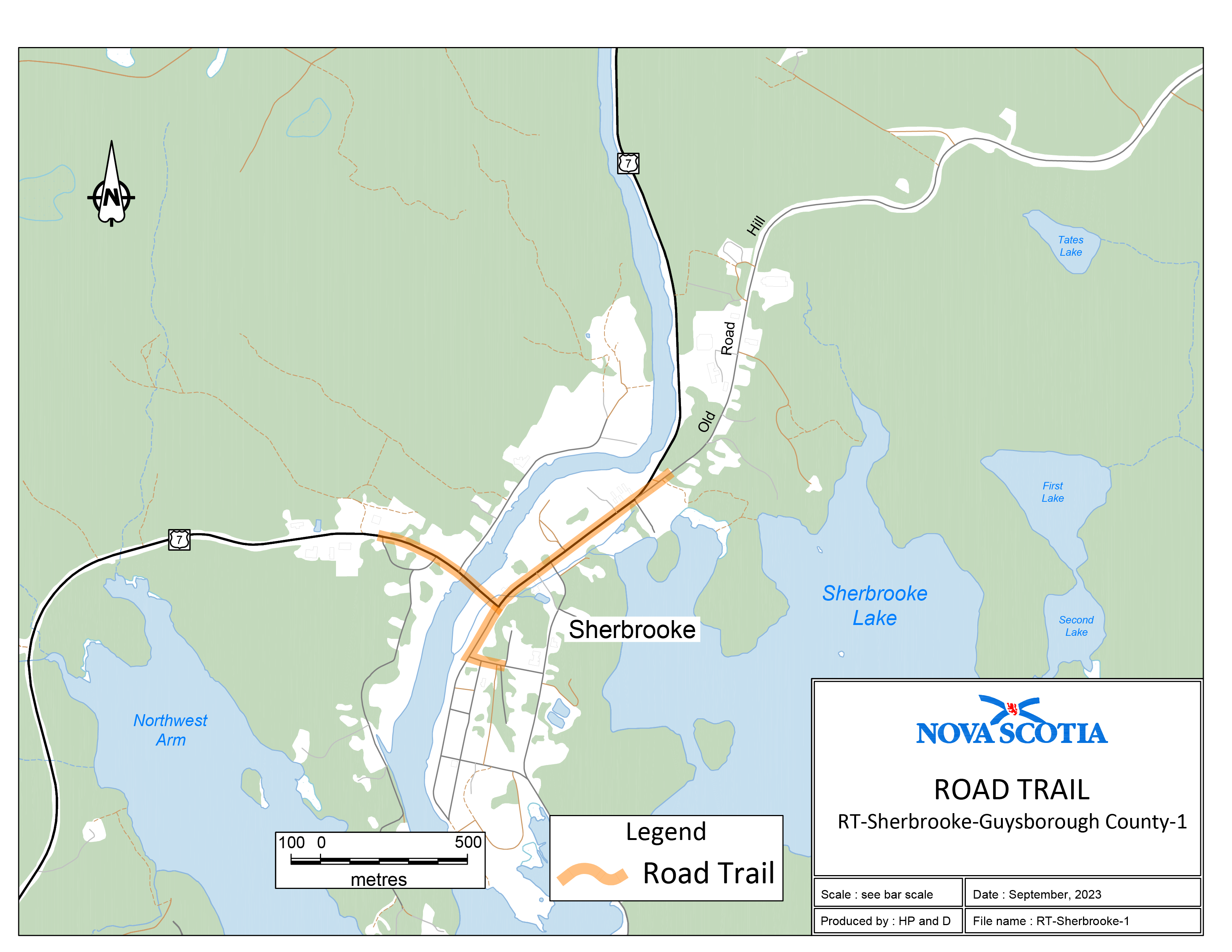
Two sections of road travel:
1. Trail intersects with Highway 7 near Sherbrooke, Guysbrough County at east 579559, north 4999516 and travels in an easterly direction along Highway 7 for 490 m to the intersection of Highway 7 and Main Street. Then northeast 635 m to the intersection of Highway 7 and Old Road Hill. Northeast along Old Road Hill 100 m to the intersection of existing trail.
2. Beginning at the Intersection of Highway 7 and Main Street, travel southwest along Main Street to the intersection of Main [Street] and Court Street. Then easterly along Court Street 90 m to east 579965, north 4999086.
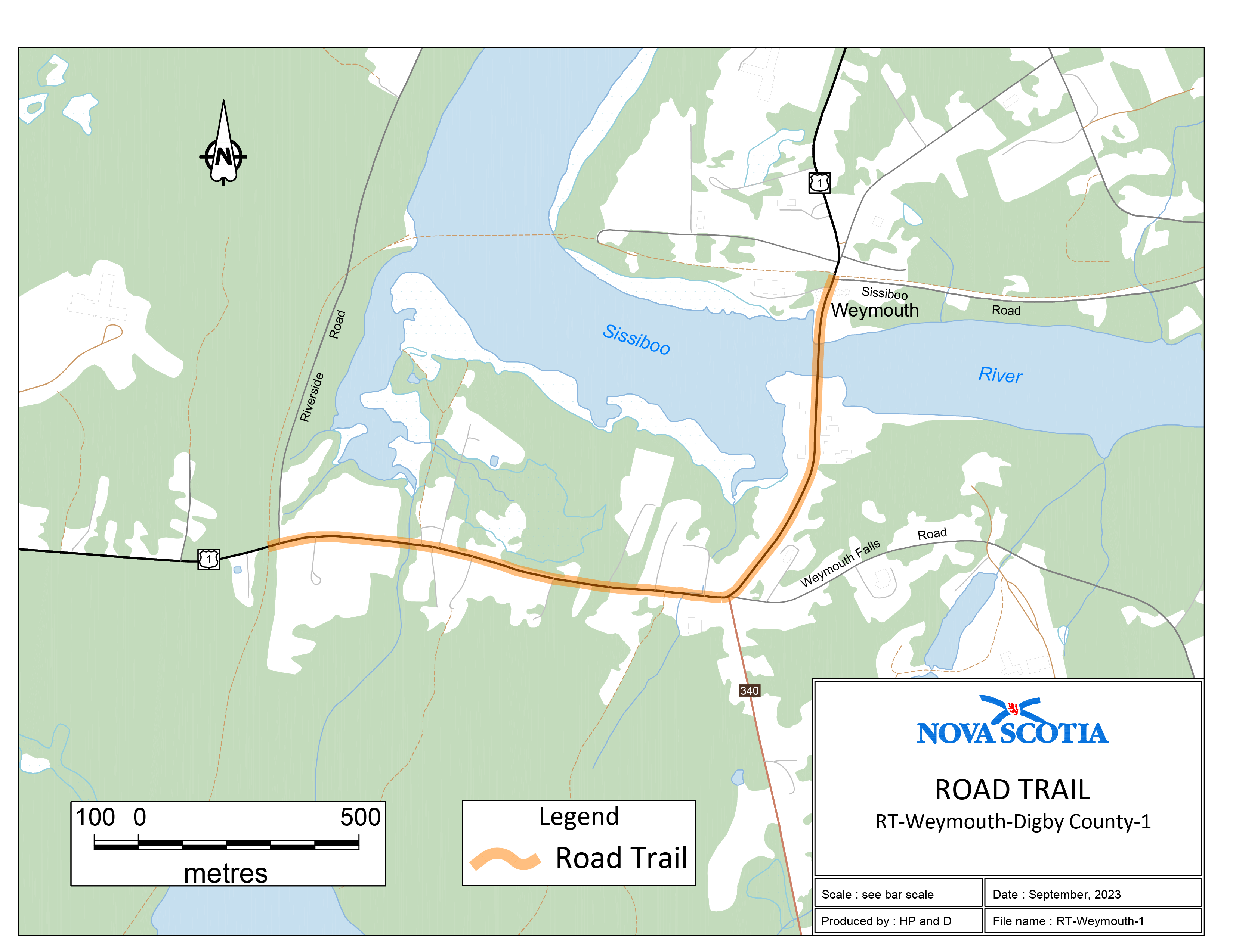
Trail begins where the former rail bed intersects with Highway 1, north of Weymouth, Digby County, at coordinates east 261483, north E 4921956. Then 810 m along Highway 1 to the intersection of Route 340, Weymouth Falls Road and Highway 1. Then westerly, 1060 m along Highway 1 to the intersection of existing trail on former rail bed at coordinates east 737944 north 4921282.
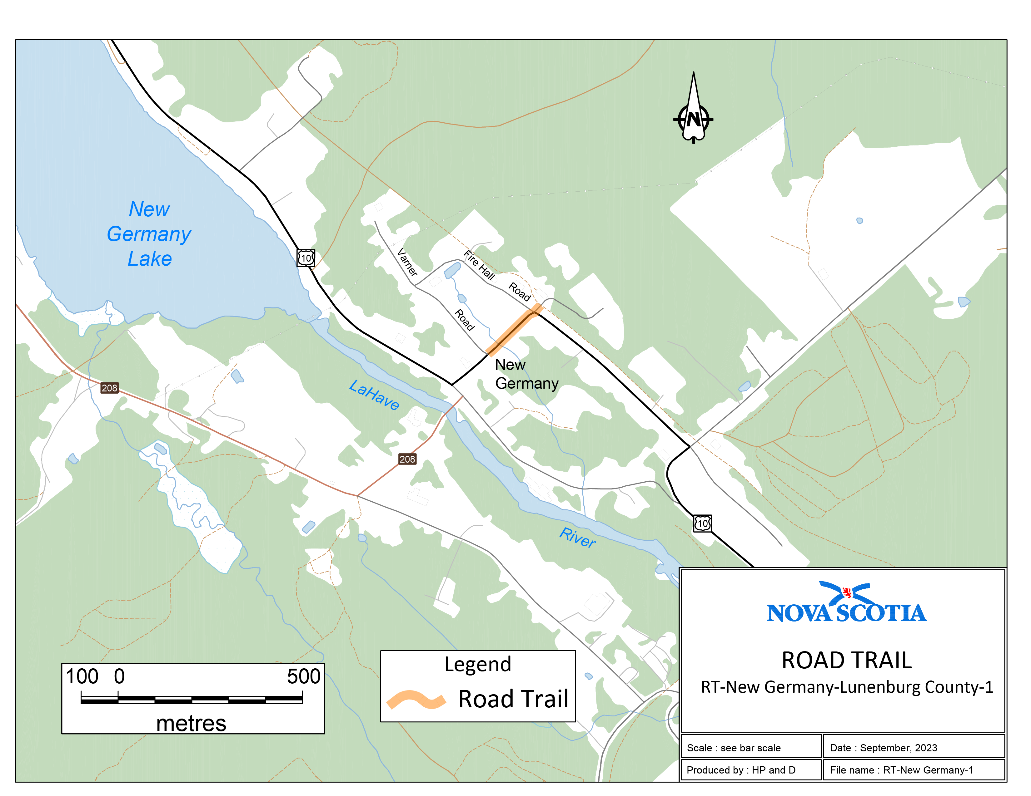
Trail begins where the former rail bed intersects with Maple Drive, New Germany (near Fire Hall), Lunenburg County, at coordinates east 363164, north 4934130. Then southwest crossing Highway 10 and travelling 210 m to the intersection of Highway 10 and Varner Road coordinates east 363012, north 4934000.
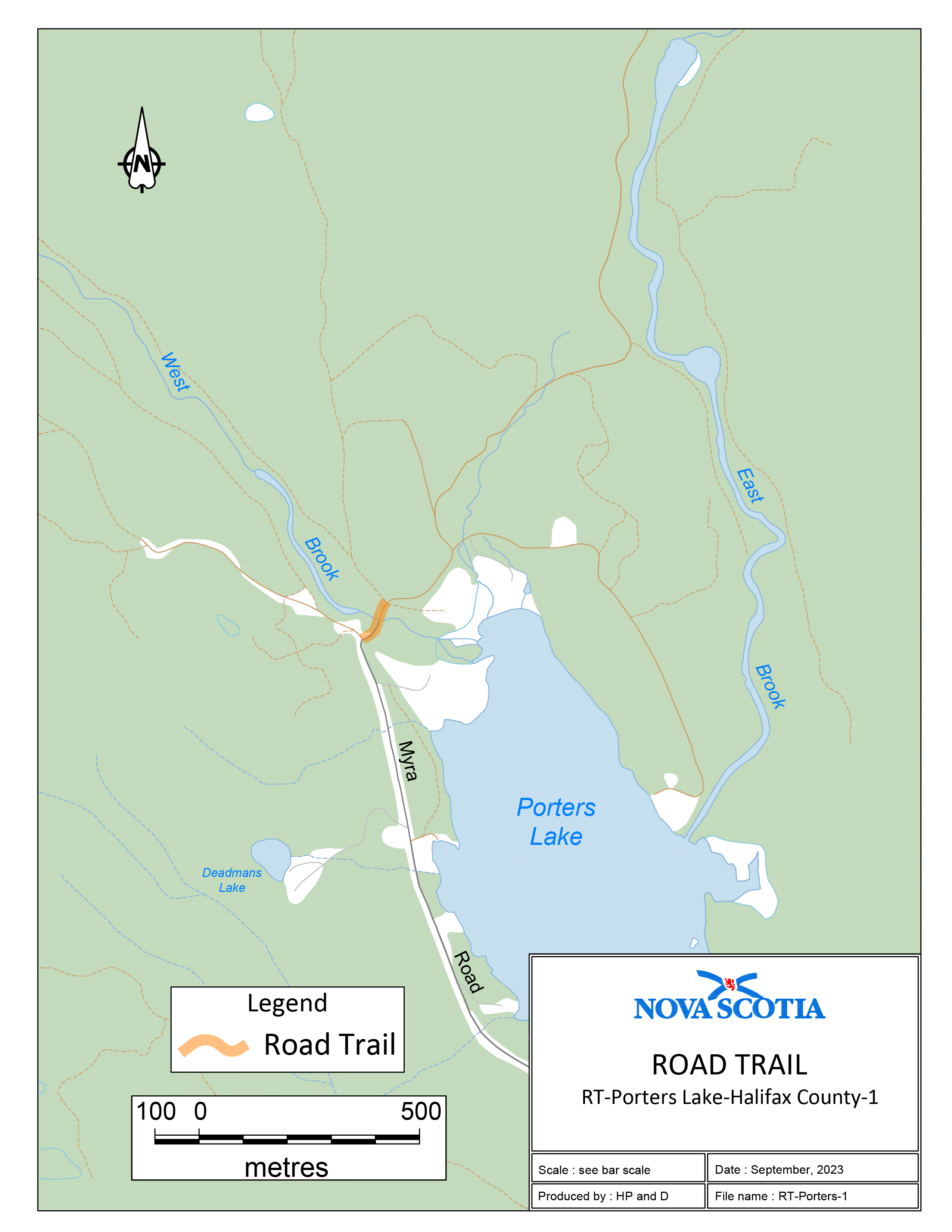
Beginning at a point on the Myra Road, Porters Lake, Halifax County, coordinates east 469553, north 4961722 and travelling in a northerly direction for 110 m to an existing trail at east 469608, north 4961806.
Two sections of road travel:
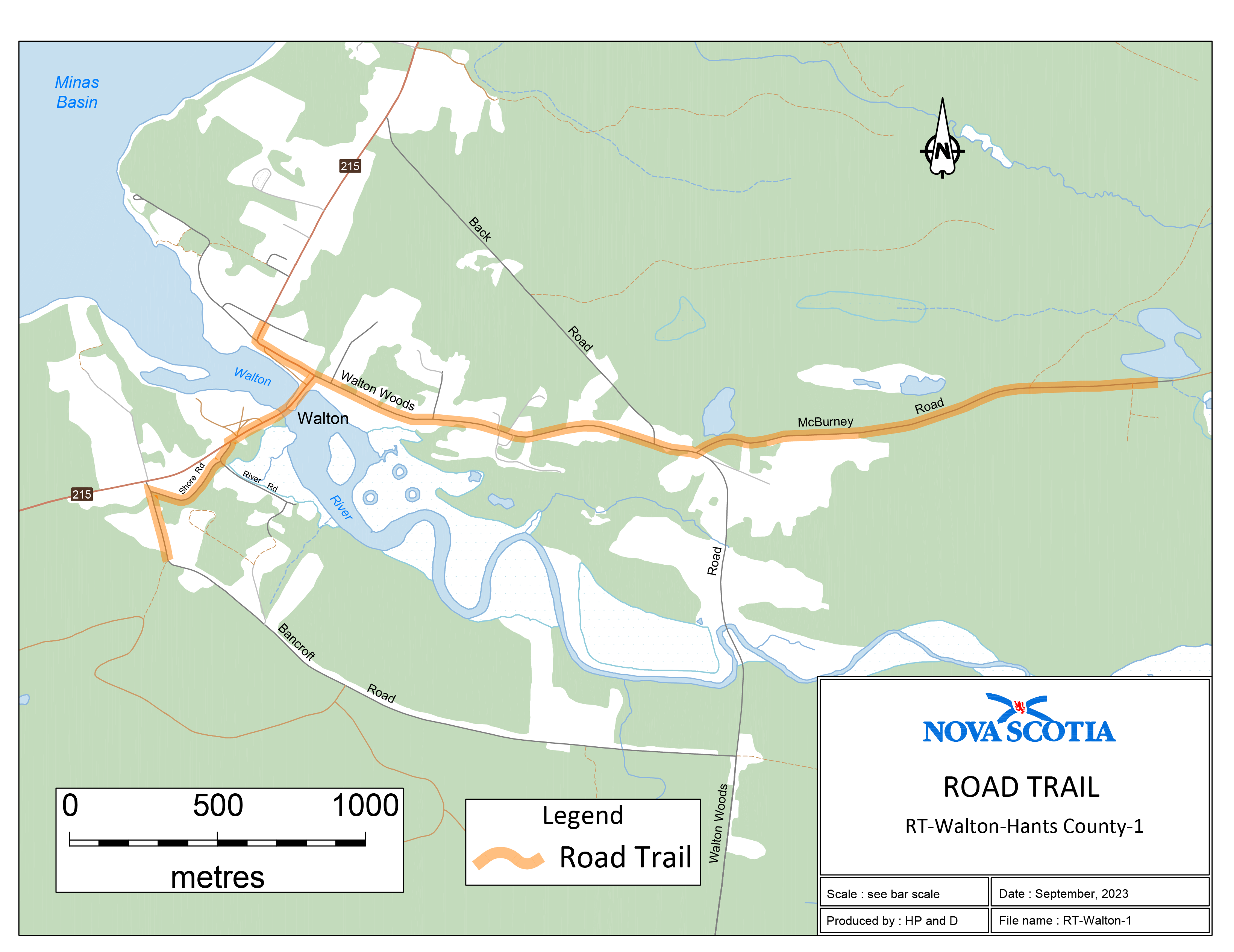
1. Trail intersects with the Bancroft Road near Walton, Hants County, at coordinates east 420682, north 5008242. Then north 250 m, along the Bancroft Road to the intersection of the Shore Road, then 375 m along the Shore Road to the intersection of Route 215. Then northeast along Route 215, 365 m to the intersection of the Walton Woods Road. Then easterly along the Walton Woods Road 1340 m to the intersection of the McBurney Road, then 1600 m along McBurney Road to coordinates east 424055, north 5008790.
2. Beginning at the intersection of Route 215 and Walton [Woods] Road, then northwest along Route 215, 290 m to the intersection of Route 215 and Odd Fellows Hall Road, coordinates east 421023, north 5009038.
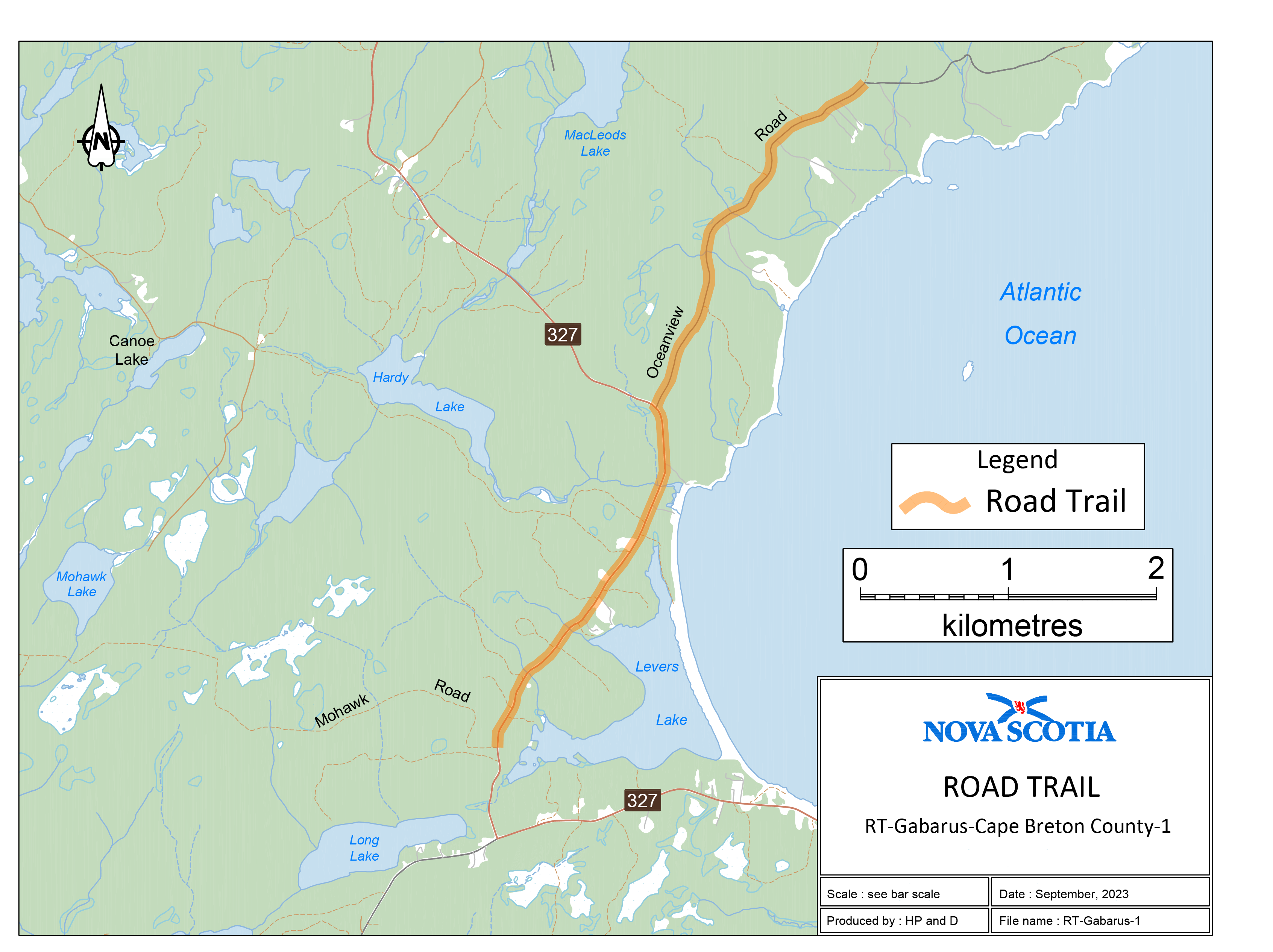
Trail begins where a K-class road intersects with Oceanview Road at east 720627, north 5084878 and travelling in a southerly direction along Oceanview Road, 2822 m to the intersection of Oceanview Road and Route 327. Then southerly along Route 327, 2667 m to the intersection of Route 327 and a Crown road at east 718244, north 5080351.
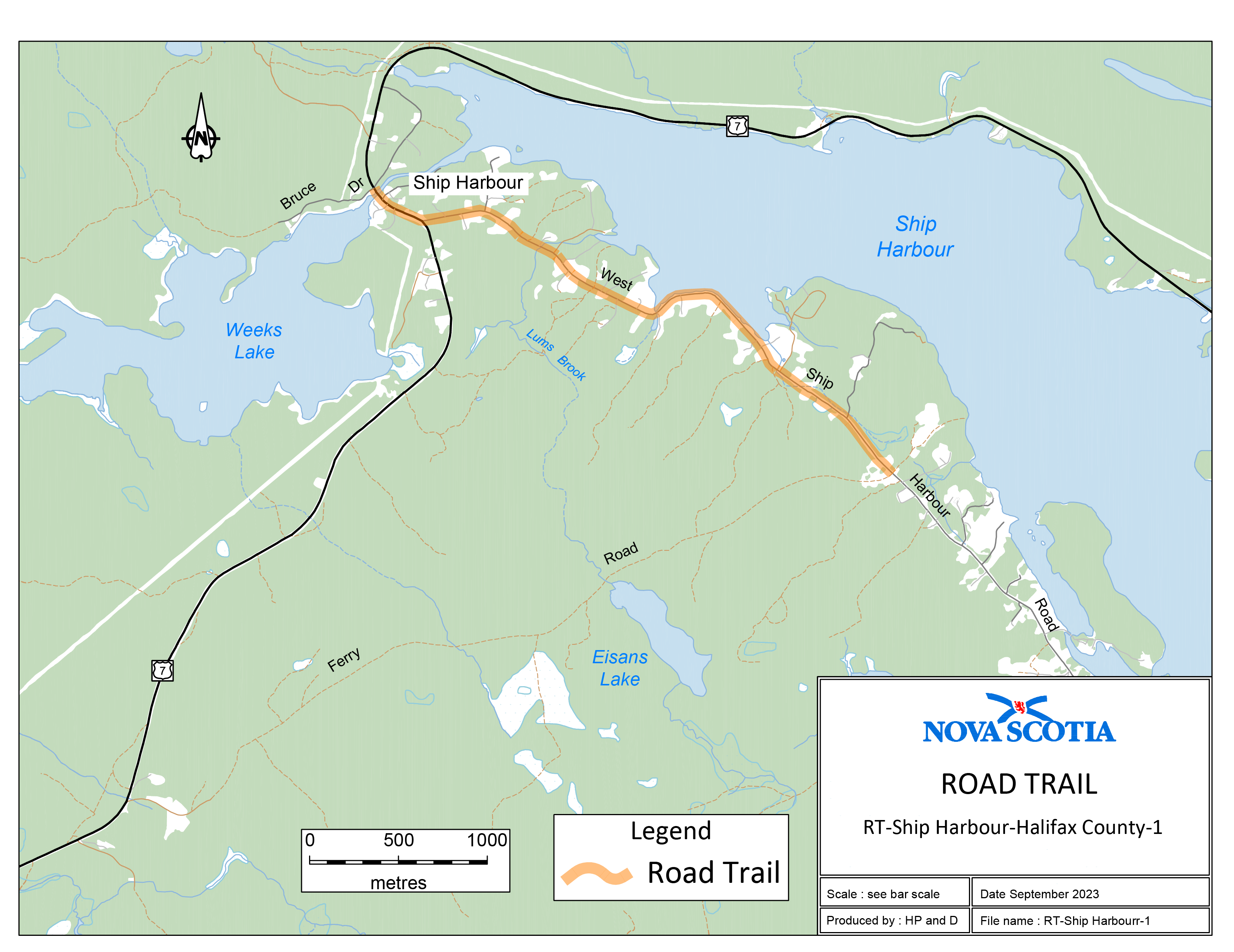
Trail begins at the location where Ferry Road (K-class road) intersects with West Ship Harbour Road at coordinates east 511962, north 4960235. Then 3300 m in a northwesterly direction along West Ship Harbour Road and Trunk 7. Then 340 m northwesterly along Trunk 7 to the intersection of Trunk 7 and Bruce Drive (a private lane) at coordinates east 509010, north 4961793.
Legislative History
Reference Tables
Road Trails Designation |
N.S. Reg. 176/2023 |
Road Trails Act |
|
Note: The information in these tables does not form part of the regulations and is compiled by the Office of the Registrar of Regulations for reference only. |
|
Source Law
The current consolidation of the Road Trails Designation made under the Road Trails Act includes all of the following regulations:
N.S. |
In force |
How in force |
Royal Gazette |
176/2023
|
Oct 2, 2023 |
date specified |
Oct 20, 2023 |
|
|
|
|
|
|
|
|
|
|
|
|
|
|
|
|
The following regulations are not yet in force and are not included in the current consolidation:
N.S. |
In force |
How in force |
Royal Gazette |
|
|
|
|
|
|
|
|
|
|
|
|
*See subsection 3(6) of the Regulations Act for
rules about in force dates of regulations.
ad. = added |
fc. = fee change |
rep. = repealed |
|
Provision affected
|
How affected
|
||
.......................................................... |
|
||
|
|
||
|
|
||
|
|
||
|
|
||
Note that changes to headings are not included in the above table.
Editorial Notes and Corrections
|
Note |
Effective |
|
|
|
|
|
|
|
|
|
Repealed and Superseded
N.S. |
Title |
In force |
Repealed |
|
|
|
|
Note: Only regulations that are specifically repealed and replaced appear in this table. It may not reflect the entire history of regulations on this subject matter.