Nova Scotia’s Wetlands
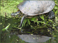 Most of us have a pretty good idea what a wetland is, even though we may not be able to provide a precise definition if asked. Wetlands are wet. That’s a simple way to put it. Most wetlands are at least soggy if not brimming with standing water for much of the year. If you are standing in one, your feet are most likely getting a good soaking unless you have rubber boots on, but this is not always the case. Some wetlands, like vernal pools and ephemeral woodland ponds, where many salamanders, frogs and turtles spend a good portion of the spring, typically dry out in summer and may or may not fill up again in the fall. Many of our forested wetlands and floodplain swamps are relatively dry for much of the year as well.
The one constant about wetlands is that they are always changing. The words of naturalist John Burroughs ring especially true for wetlands, "if you want an adventure in nature, take the same walk that you took yesterday, and do so again tomorrow." If you want to see something new today, go back to the same wetland you visited yesterday. Visiting a wetland from week to week and season to season you will observe many different "personality traits" of the wetland that make up its overall character. From changing degrees of sogginess, to the many different kinds of plants that flower in different seasons, to the sorts of animals that are likely to be breeding, scrounging for food or hibernating there. The variable nature of wetlands makes them especially interesting places to visit throughout the year, but also particularly tricky to pin down with a precise definition.
Wetland Definition
The definition we use for wetlands in Nova Scotia is:
Land commonly referred to as marsh, swamp, fen or bog that either periodically or permanently has a water table at, near or above the land's surface or that is saturated with water, and sustains aquatic processes as indicated by the presence of poorly drained soils, hydrophytic vegetation and biological activities adapted to wet conditions. - Environment Act as amended in 2006.
There are many different types of wetlands, each with a unique set of ecological characters and conditions. However, wetlands can be characterized generally as habitats with water at or near the surface (<2 m deep), little or no current (water flow), plants and animals that thrive in wet conditions, and places with typically rich soils that develop where water saturates or floods the surface at least seasonally.
Because of their tendency to "bog" people down or to get people "mired" or "swamped", the incredibly important ecological values associated with wetlands have often been overlooked.
Wetland Functions and Services
We now realize that wetlands perform many important functions and services in our landscapes such as, improving water quality, controlling floods, recharging groundwater, protecting coastal infrastructure and providing critical habitat for rare and endangered species. Wetlands are also among the most productive and diverse of all the ecosystems on earth, so the loss of wetlands can mean the loss of species or local populations of fish, wildlife and plants that depend on them for habitat or food. Because many of Nova Scotia’s wetlands have already been lost due to various human activities (e.g., over half of all original salt marsh habitat has been converted to other uses), wetlands that remain take on a heightened level of importance.
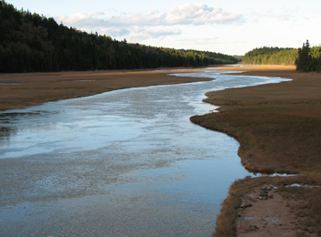 Despite the great number that have been lost to conversion, our salt marshes are still a particularly important wetland type in Nova Scotia. They support a diverse array of plants and animals, sequester carbon efficiently (potentially reducing greenhouse gas impacts), protect coastlines, coastal roads and buildings from the potentially devastating effects of storm surges and can play an important role in supporting coastal fisheries.
There is an excellent discussion of the different types of wetlands we have in Nova Scotia and the many functions and services they perform on the NS Wet Places website.
Wetland Types and Inventory
A province-wide wetland inventory completed by the Nova Scotia Department of Natural Resources in 2004 provides the most up-to-date estimate of the number and area of different wetland types in the province. The inventory is based upon visual interpretation of 1:10,000 scale aerial photographs taken between 1998 and 2001. The wetland inventory is available online.
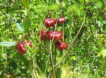 There is no doubt about it, Nova Scotia is rich in wetlands. Based on the 2004 inventory, Nova Scotia’s 5.5 million hectares of land is comprised of 360,462 hectares (6.6% of total land area) of freshwater wetlands and 17,060 hectares (0.3% of total land area) of salt marsh. Over three-quarters of our wetlands are peatlands (bogs and fens), famous around the world for their size, for the cranberries that grow in them as well as their peat. The next most common types of wetlands are shrub swamps (10.1%) and salt marshes (4.5%) being the only other types comprising more than 3% of our provincial total. Our rarest types are freshwater marshes, lakeshore wetlands, wet meadows and seasonally flooded flats along rivers. Each of these different types of wetlands functions somewhat differently and supports a unique array of plants and wildlife.
It is important to realize that the location of wetlands on the landscape is constantly evolving and the accuracy of the NSDNR wetland inventory is not sufficient to be relied on exclusively when trying to determine the location of wetlands at a potential project site. Field confirmation of wetland location and size is crucial when evaluating the suitability of a site for any particular project. However, the NSDNR forest inventory and Wet Areas Mapping tools are additional online tools that can be downloaded and used to help identify and predict where wetlands are likely to be located within the province.
Wetlands of Special Importance
Salt marshes located primarily along Northumberland, Fundy and Atlantic coasts, freshwater peatlands along the Atlantic coast, as well as lake-edge wetlands and wetlands (mainly in southwestern Nova Scotia) that support globally rare coastal plain flora, are among the most ecologically significant and unique wetlands in the province. Nova Scotia also has three wetland complexes designated as Wetlands of International Importance under the Ramsar Convention on Wetlands. The three wetland complexes are:
1. Southern Bight, Minas Basin (26,800 ha) - supports the largest numbers of mixed species of shoreline birds during fall migration in all of North America;
2. Musquodoboit Harbour (1,925 ha) - a salt marsh with extensive eelgrass beds that provide cover and nutrients to support abundant invertebrates, coastal fisheries and food webs and wintering waterbirds; and,
3. Chignecto National Wildlife Area (1,025 ha) - a salt marsh dissected by numerous tidal creeks and freshwater wetlands that play an important role in suppling nutrients to coastal waters and moderating storm surges as well as providing staging areas for migrating waterfowl. This wildlife area is in the southeast portion of the Tantramar marshes.
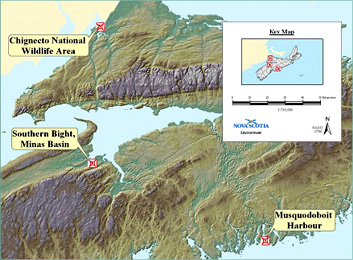 Locations of Ramsar Wetlands of International Importance in Nova Scotia.
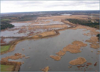 Chignecto National Wildlife Area near Amherst Point.
Common Wetland Types in Nova Scotia
Because there are a variety of wetland types present in Nova Scotia that differ considerably in their appearance and typical location in the landscape, it can be difficult to know what someone is referring to when they use the word "wetland". The Canadian Wetland Classification System provides a detailed description of all wetland types present in Canada, but here is a summary for those wetland types that are common in Nova Scotia:
Bog
Wetlands characterized by the accumulation of Sphagnum moss as peat. The bog surface, which is raised or level with the surrounding terrain, is virtually unaffected by surface runoff or groundwater from the surrounding terrain. Generally the water table is at or slightly below the bog surface. As natural processes raise the bog surface, the water table in the bog rises relative to the elevation of the water table at the edges of the bog. Precipitation, fog and snowmelt are the primary water sources. Bog waters are low in dissolved minerals and acidic (usually between pH 4.0 and 4.8). Bogs may be treed (black spruce and tamarck can be common) or treeless, and they are usually covered with Sphagnum spp. and ericaceous shrubs such as, leatherleaf, huckleberry, lambkill and Labrador tea. Cranberry, crowberry, pitcher-plant and cotton-grass are common in more open bogs.
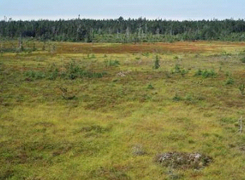 Shelburne-area bog.
Fen
Ground or surface water-fed peatlands saturated with water and typically dominated by sedges and brown mosses. Groundwater and surface water movement is a common characteristic that distinguishes fens from bogs. Surface flow may be directed through channels, pools, and other open water bodies. The vegetation in fens is more diverse than in bogs and closely related to the depth of the water table and water chemistry. In general, sedges and mosses dominate wetter fens where the water table is above the surface. Shrubby trees such as tamarack, birch and willow are prominent in drier fens. Black spruce are common on the driest fen sites where moss hummocks provide microhabitats above the water table.
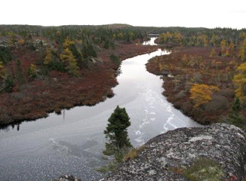 Shrub fen along a stillwater brook.
Coastal Saline Pond
A saline to brackish pond commonly found behind a barrier beach or bar formed of sand or cobble deposited by wave action that receives saline water by storm surge, spray or by regular or periodic opening to the ocean. This includes saline ponds often referred to as barachois ponds and tidal lagoons. Typical saline ponds are isolated from breaching, have no outlet and their saline influence is from spray and storm surge. Barachois ponds exist where the barrier is occasionally breached and also receive input from spray and storm surges. Tidal lagoons are semi-enclosed and receive saline input on regular or spring tides. Barachois ponds and tidal lagoons may also receive freshwater input from streams, while typical saline ponds receive inputs only from overland flow and groundwater.
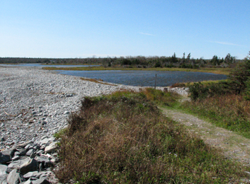 Saline pond along the eastern shore
Marsh
A shallow-water wetland with water levels that fluctuate daily, seasonally or annually, occasionally drying up or exposing sediments. Marshes receive their water from the surrounding watershed as surface runoff, stream inflow, precipitation, storm surges, groundwater discharge, longshore currents and tidal action. High nutrient levels give rise to high vascular plant productivity and high decomposition rates at the end of the growing season. Marshes that are seasonally dry or exposed to high energy currents or tides usually accumulate little organic matter, but wetter more stable and permanently saturated marshes such as in lakeshore embayment and groundwater-fed basin marshes can accumulate organic material to depths around 50 cm. Emergent aquatic plants (macrophytes) such as rushes, reeds, grasses and sedges, as well as floating and submerged aquatic macrophytes, and non-vascular plants such as brown mosses, liverworts, and macroscopic algae are typical of marshes.
Deep, shallow and shoreline marshes are typically non tidal and freshwater, whereas salt marshes are tidal and saline.
Deep marsh - wetlands with an average water depth between 15 cm and 1 m during the growing season. Emergent marsh vegetation (e.g., rushes, bulrushes) is usually dominant, with surface and submergent plants present in deeper areas.
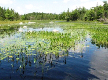 Deep marsh in the bay of a lake.
Shallow marsh - wetlands often dominated by robust emergent plants (cattails, arrowhead), with an average water depth less than 15 cm during the growing season. Wet meadow habitats, usually dominated by sedges and grasses, are typically the driest of the shallow marshes and often transitional to shrub and wooded swamps adjacent to the marsh. Surface water may be absent during the late summer and abnormally dry periods. Floating-leaved and submerged plants can be present in deeper areas.
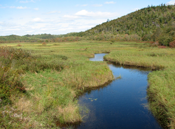 Shallow marsh.
Salt marsh - vegetated wetland that is flooded regularly by tidal water, or influenced by salt spray or seepage, such that the water and/or soil is saline or brackish. Tidal channels and/or ponds may be present. Salt-water cordgrass (Spartina alterniflora) and other saline tolerant grasses and sedges often dominate low marshes, which are flooded regularly. High marshes are often flooded only during extreme tides and typically dominated by salt meadow cordgrass (Spartina patens). These are extremely productive wetlands that provide many critical environmental, societal and economic functions and services.
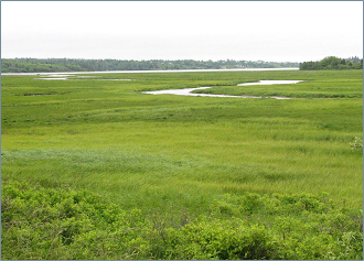 Salt marsh along the eastern shore.
Shoreline marsh - include areas in or along lakes, ponds, rivers and streams with water less than 2 m deep and scattered emergent vegetation. These areas often have floating or submerged aquatic plants and mucky or mineral substrates. These wetlands are also referred to as lacustrine (along lakes and ponds) or riparian (along streams and rivers) marshes. The deeper portions of these habitats are also referred to as shallow open water wetlands.
Swamp
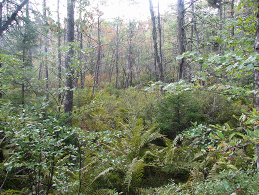 Red maple swamp in Clayton Park
Wetlands dominated by trees and shrubs with generally over 30% cover in woody species, wood-rich peat or mineral soils and water tables typically at or below the surface. They may be seasonally or permanently flooded with as much as 30 cm of water. Swamps are generally not as wet as marshes, fens and the open bogs. They are common along the drier portions of floodplains and riparian areas of rivers and streams. Nutrient regimes are highly variable and pH ranges from around 4.5 to above 7.0.
In shrub swamps, shrubs occupy more than half of the habitat with sedges as the typical ground cover. Grasses, sedges or rushes commonly occupy open areas. In wooded swamps, trees dominate, but there are usually several other levels of vegetation, including shrubs, ferns and a variety of herbaceous plants. Trees and many shrubs grow on slightly drier areas while marsh emergents and ferns occupy the vernal pools. Along with treed bogs and fens, wooded swamps are among Nova Scotia's most common forested wetlands.
Vernal Pools
These are small (typically less than 0.5 ha), shallow wetlands that lack permanent inlet or outlet streams and often dry out in the summer. They provide critical breeding habitat for frogs, salamanders, insects and fairy shrimp and feeding and drinking sites for birds, mammals, turtles and other wildlife.
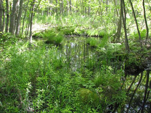 Vernal pool near York Redoubt.

